

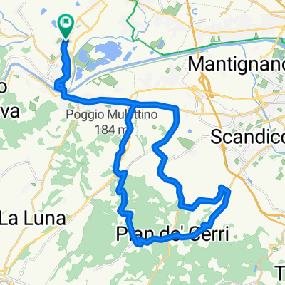
Signa Villa Sangallo Poggio a Caiano Visitazione del Pontormo Carmignano
A cycling route starting in Signa, Tuscany, Italy.
Overview
About this route
23 km di cultura tra la villa di Sangallo a Poggio a Caiano con lo splendido giardino mediceo e la Visitazione del Pontormo a Carmignano! per poi concludere la giornata riposandovi da noi! HOTEL DELFINA
- -:--
- Duration
- 22.9 km
- Distance
- 365 m
- Ascent
- 361 m
- Descent
- ---
- Avg. speed
- ---
- Max. altitude
Continue with Bikemap
Use, edit, or download this cycling route
You would like to ride Signa Villa Sangallo Poggio a Caiano Visitazione del Pontormo Carmignano or customize it for your own trip? Here is what you can do with this Bikemap route:
Free features
- Save this route as favorite or in collections
- Copy & plan your own version of this route
- Sync your route with Garmin or Wahoo
Premium features
Free trial for 3 days, or one-time payment. More about Bikemap Premium.
- Navigate this route on iOS & Android
- Export a GPX / KML file of this route
- Create your custom printout (try it for free)
- Download this route for offline navigation
Discover more Premium features.
Get Bikemap PremiumFrom our community
Other popular routes starting in Signa
 Percorso nel Chianti Montespertoli
- Distance
- 43.3 km
- Ascent
- 414 m
- Descent
- 349 m
- Location
- Signa, Tuscany, Italy
 santil sammart
- Distance
- 31.5 km
- Ascent
- 543 m
- Descent
- 544 m
- Location
- Signa, Tuscany, Italy
 Signa Vitolini Poggio
- Distance
- 53.2 km
- Ascent
- 552 m
- Descent
- 552 m
- Location
- Signa, Tuscany, Italy
 Signa Chianti Montespertoli
- Distance
- 48.2 km
- Ascent
- 387 m
- Descent
- 373 m
- Location
- Signa, Tuscany, Italy
 Giro a velocità lenta in Signa
- Distance
- 17.5 km
- Ascent
- 58 m
- Descent
- 60 m
- Location
- Signa, Tuscany, Italy
 Raduno Lama
- Distance
- 81.1 km
- Ascent
- 811 m
- Descent
- 811 m
- Location
- Signa, Tuscany, Italy
 Percorso per ¿œ·⁄?
- Distance
- 14.5 km
- Ascent
- 0 m
- Descent
- 13 m
- Location
- Signa, Tuscany, Italy
 Raduno Lama Lungo
- Distance
- 130.7 km
- Ascent
- 1,134 m
- Descent
- 1,134 m
- Location
- Signa, Tuscany, Italy
Open it in the app