
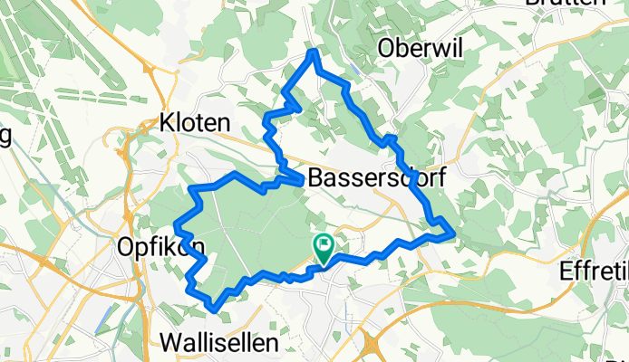
Rund um Bassersdorf
A cycling route starting in Dietlikon / Eichwiesen, Canton of Zurich, Switzerland.
Overview
About this route
Kurze MTB Runde um Bassersdorf, die es aber bei entsprechendem Tempo in sich hat. Vorallem Waldwege und kurze Trails, immer wieder schöne Ausblicke.
- -:--
- Duration
- 20.4 km
- Distance
- 203 m
- Ascent
- 201 m
- Descent
- ---
- Avg. speed
- ---
- Max. altitude
Continue with Bikemap
Use, edit, or download this cycling route
You would like to ride Rund um Bassersdorf or customize it for your own trip? Here is what you can do with this Bikemap route:
Free features
- Save this route as favorite or in collections
- Copy & plan your own version of this route
- Sync your route with Garmin or Wahoo
Premium features
Free trial for 3 days, or one-time payment. More about Bikemap Premium.
- Navigate this route on iOS & Android
- Export a GPX / KML file of this route
- Create your custom printout (try it for free)
- Download this route for offline navigation
Discover more Premium features.
Get Bikemap PremiumFrom our community
Other popular routes starting in Dietlikon / Eichwiesen
 Ringstrasse 16, Brüttisellen nach Ringstrasse 18, Brüttisellen
- Distance
- 15.7 km
- Ascent
- 68 m
- Descent
- 69 m
- Location
- Dietlikon / Eichwiesen, Canton of Zurich, Switzerland
 Feierabendtour
- Distance
- 13.8 km
- Ascent
- 183 m
- Descent
- 147 m
- Location
- Dietlikon / Eichwiesen, Canton of Zurich, Switzerland
 Halber See und etwas Hügel
- Distance
- 67.8 km
- Ascent
- 345 m
- Descent
- 334 m
- Location
- Dietlikon / Eichwiesen, Canton of Zurich, Switzerland
 Winterthur hügelig
- Distance
- 42.6 km
- Ascent
- 674 m
- Descent
- 674 m
- Location
- Dietlikon / Eichwiesen, Canton of Zurich, Switzerland
 Kleine Radtour
- Distance
- 13.2 km
- Ascent
- 96 m
- Descent
- 96 m
- Location
- Dietlikon / Eichwiesen, Canton of Zurich, Switzerland
 Sunntigshöger
- Distance
- 48.8 km
- Ascent
- 489 m
- Descent
- 498 m
- Location
- Dietlikon / Eichwiesen, Canton of Zurich, Switzerland
 Route im Schneckentempo in Dietlikon
- Distance
- 3.8 km
- Ascent
- 24 m
- Descent
- 24 m
- Location
- Dietlikon / Eichwiesen, Canton of Zurich, Switzerland
 Rund um den Greifensee
- Distance
- 35.8 km
- Ascent
- 98 m
- Descent
- 98 m
- Location
- Dietlikon / Eichwiesen, Canton of Zurich, Switzerland
Open it in the app