

Fürstenzell - wildpark Ortenburg
A cycling route starting in Fürstenzell, Bavaria, Germany.
Overview
About this route
No further details yet, I will ride it for the first time in the coming days
- -:--
- Duration
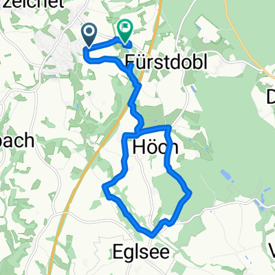
- 8.9 km
- Distance
- 195 m
- Ascent
- 143 m
- Descent
- ---
- Avg. speed
- ---
- Max. altitude
Route quality
Waytypes & surfaces along the route
Waytypes
Track
2.8 km
(31 %)
Road
2.4 km
(27 %)
Surfaces
Paved
1 km
(11 %)
Unpaved
1.6 km
(18 %)
Gravel
1.3 km
(14 %)
Asphalt
1 km
(11 %)
Continue with Bikemap
Use, edit, or download this cycling route
You would like to ride Fürstenzell - wildpark Ortenburg or customize it for your own trip? Here is what you can do with this Bikemap route:
Free features
- Save this route as favorite or in collections
- Copy & plan your own version of this route
- Sync your route with Garmin or Wahoo
Premium features
Free trial for 3 days, or one-time payment. More about Bikemap Premium.
- Navigate this route on iOS & Android
- Export a GPX / KML file of this route
- Create your custom printout (try it for free)
- Download this route for offline navigation
Discover more Premium features.
Get Bikemap PremiumFrom our community
Other popular routes starting in Fürstenzell
 Fürstenzell - wildpark Ortenburg
- Distance
- 8.9 km
- Ascent
- 195 m
- Descent
- 143 m
- Location
- Fürstenzell, Bavaria, Germany
 A3, Neuburg am Inn nach A3, Fürstenzell
- Distance
- 0.3 km
- Ascent
- 0 m
- Descent
- 3 m
- Location
- Fürstenzell, Bavaria, Germany
 Schwimmbad Fürstenzell
- Distance
- 7.1 km
- Ascent
- 107 m
- Descent
- 101 m
- Location
- Fürstenzell, Bavaria, Germany
 Kohlbruck-Wernstein-Neukirchen
- Distance
- 35.2 km
- Ascent
- 428 m
- Descent
- 428 m
- Location
- Fürstenzell, Bavaria, Germany
 Gründoblweg, Fürstenzell nach Eichendorffstraße 23, Passau
- Distance
- 5.4 km
- Ascent
- 115 m
- Descent
- 207 m
- Location
- Fürstenzell, Bavaria, Germany
 Entspannte Route
- Distance
- 37.7 km
- Ascent
- 347 m
- Descent
- 342 m
- Location
- Fürstenzell, Bavaria, Germany
 eglsee runde
- Distance
- 12.2 km
- Ascent
- 210 m
- Descent
- 233 m
- Location
- Fürstenzell, Bavaria, Germany
 Arbeit_2
- Distance
- 19.9 km
- Ascent
- 250 m
- Descent
- 308 m
- Location
- Fürstenzell, Bavaria, Germany
Open it in the app