

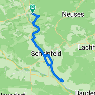
Prühl - Burghaslach und zurück
A cycling route starting in Oberscheinfeld, Bavaria, Germany.
Overview
About this route
Prühl - Appenfelden - Oberrimbach - Unterrimbach - Burghaslach - Freihaslach - Münchhof - Burghöchstadt - Haag - Prühl
- -:--
- Duration
- 27 km
- Distance
- 335 m
- Ascent
- 336 m
- Descent
- ---
- Avg. speed
- ---
- Max. altitude

Route quality
Waytypes & surfaces along the route
Waytypes
Road
5.1 km
(19 %)
Track
0.5 km
(2 %)
Surfaces
Paved
17.3 km
(64 %)
Asphalt
17.3 km
(64 %)
Undefined
9.7 km
(36 %)
Continue with Bikemap
Use, edit, or download this cycling route
You would like to ride Prühl - Burghaslach und zurück or customize it for your own trip? Here is what you can do with this Bikemap route:
Free features
- Save this route as favorite or in collections
- Copy & plan your own version of this route
- Sync your route with Garmin or Wahoo
Premium features
Free trial for 3 days, or one-time payment. More about Bikemap Premium.
- Navigate this route on iOS & Android
- Export a GPX / KML file of this route
- Create your custom printout (try it for free)
- Download this route for offline navigation
Discover more Premium features.
Get Bikemap PremiumFrom our community
Other popular routes starting in Oberscheinfeld
 Prühl - Burghaslach und zurück
- Distance
- 27 km
- Ascent
- 335 m
- Descent
- 336 m
- Location
- Oberscheinfeld, Bavaria, Germany
 Am Schloßberg nach Am Schloßberg
- Distance
- 23.4 km
- Ascent
- 88 m
- Descent
- 140 m
- Location
- Oberscheinfeld, Bavaria, Germany
 Schwanberg alternative
- Distance
- 34.4 km
- Ascent
- 181 m
- Descent
- 244 m
- Location
- Oberscheinfeld, Bavaria, Germany
 12.10. 40 km in der Nähe
- Distance
- 42.2 km
- Ascent
- 225 m
- Descent
- 216 m
- Location
- Oberscheinfeld, Bavaria, Germany
 Lerchenweg 12, Oberscheinfeld nach Hörblacher Straße 13, Dettelbach
- Distance
- 29.6 km
- Ascent
- 168 m
- Descent
- 340 m
- Location
- Oberscheinfeld, Bavaria, Germany
 Erlabronn - Appenfelden - Erlabronn
- Distance
- 15.1 km
- Ascent
- 285 m
- Descent
- 283 m
- Location
- Oberscheinfeld, Bavaria, Germany
 Oberscheinfeld - Iphofen - Oberscheinfeld
- Distance
- 43.2 km
- Ascent
- 271 m
- Descent
- 271 m
- Location
- Oberscheinfeld, Bavaria, Germany
 NEA25, Oberscheinfeld nach Hohlgasse 5, Oberscheinfeld
- Distance
- 15.5 km
- Ascent
- 166 m
- Descent
- 166 m
- Location
- Oberscheinfeld, Bavaria, Germany
Open it in the app