
Zürcher Unterland
A cycling route starting in Freienbach, Canton of Schwyz, Switzerland.
Overview
About this route
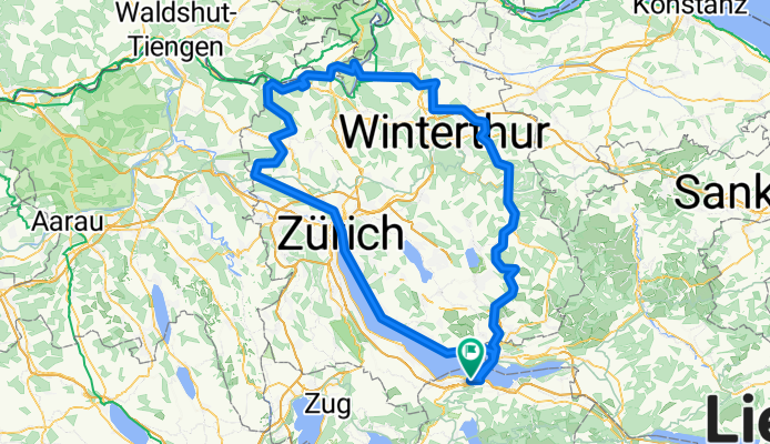
über Zürich ins Wehn- und ins Furttal, über die Lägern nach Regensberg. Von dort an und über den Rhein nach Eglisau, Winland, Seuzach, Elsau und Oberhittnau zurück.
Das ist erst eine Grobskizze, damit ihr die Distanz und die HM abschätzen könnt.
- -:--
- Duration
- 169.5 km
- Distance
- 1,952 m
- Ascent
- 1,837 m
- Descent
- ---
- Avg. speed
- 769 m
- Max. altitude

Route quality
Waytypes & surfaces along the route
Waytypes
Road
68.7 km
(41 %)
Busy road
54.8 km
(32 %)
Surfaces
Paved
150.7 km
(89 %)
Unpaved
2 km
(1 %)
Asphalt
149 km
(88 %)
Ground
1.4 km
(<1 %)
Continue with Bikemap
Use, edit, or download this cycling route
You would like to ride Zürcher Unterland or customize it for your own trip? Here is what you can do with this Bikemap route:
Free features
- Save this route as favorite or in collections
- Copy & plan your own version of this route
- Split it into stages to create a multi-day tour
- Sync your route with Garmin or Wahoo
Premium features
Free trial for 3 days, or one-time payment. More about Bikemap Premium.
- Navigate this route on iOS & Android
- Export a GPX / KML file of this route
- Create your custom printout (try it for free)
- Download this route for offline navigation
Discover more Premium features.
Get Bikemap PremiumFrom our community
Other popular routes starting in Freienbach
 Bikerunde
- Distance
- 40.7 km
- Ascent
- 1,169 m
- Descent
- 1,168 m
- Location
- Freienbach, Canton of Schwyz, Switzerland
 RT_Hütten-Aegerisee-Raten_51-900
- Distance
- 51.1 km
- Ascent
- 898 m
- Descent
- 898 m
- Location
- Freienbach, Canton of Schwyz, Switzerland
 MTB Obersee
- Distance
- 47 km
- Ascent
- 606 m
- Descent
- 619 m
- Location
- Freienbach, Canton of Schwyz, Switzerland
 RT_BucheneggThurlerseeHirzel_65-800
- Distance
- 65.5 km
- Ascent
- 799 m
- Descent
- 799 m
- Location
- Freienbach, Canton of Schwyz, Switzerland
 Pfäffikon-Greifensee-Pfäffikon
- Distance
- 66.5 km
- Ascent
- 597 m
- Descent
- 597 m
- Location
- Freienbach, Canton of Schwyz, Switzerland
 StG Pfäffikon-Altendorf-Bilsten-Schwändi-Pfäffikon
- Distance
- 14.9 km
- Ascent
- 443 m
- Descent
- 443 m
- Location
- Freienbach, Canton of Schwyz, Switzerland
 RT_Zürichsee-Obersee_90-100
- Distance
- 90.9 km
- Ascent
- 125 m
- Descent
- 125 m
- Location
- Freienbach, Canton of Schwyz, Switzerland
 Atzännig- Ricken Flurin
- Distance
- 67.4 km
- Ascent
- 672 m
- Descent
- 670 m
- Location
- Freienbach, Canton of Schwyz, Switzerland
Open it in the app