

Jochpass-Schwarzental-Jochpass-Engelberg
A cycling route starting in Engelberg, Canton of Obwalden, Switzerland.
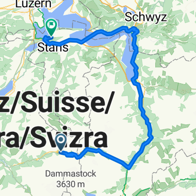
Overview
About this route
Bike to Aelplerseil ca. 300m, 9 km. 35 Min. Travel time from camping Einenwäldli.Take (cable car) Untertrübsee - Obertrübsee. Then seat lift to top of Jochpass,Bike trail to Engstlensee. At Engstlenhotel take hikers path on left side - follow single trail towards Schwarzenalp.Bike back up tar road to Engstlensee, then follow path to seat lift station.Take seat lift to top of Jochpass. Bike down Trudi's trail to Trübsee and then take single trails to Engelberg.Nearly 2000m downhill trails. 37 Km, 1000m, 3h15 riding time (excluding cable cars and seat lifts)
- -:--
- Duration
- 27.1 km
- Distance
- 913 m
- Ascent
- 2,092 m
- Descent
- ---
- Avg. speed
- ---
- Max. altitude

Continue with Bikemap
Use, edit, or download this cycling route
You would like to ride Jochpass-Schwarzental-Jochpass-Engelberg or customize it for your own trip? Here is what you can do with this Bikemap route:
Free features
- Save this route as favorite or in collections
- Copy & plan your own version of this route
- Sync your route with Garmin or Wahoo
Premium features
Free trial for 3 days, or one-time payment. More about Bikemap Premium.
- Navigate this route on iOS & Android
- Export a GPX / KML file of this route
- Create your custom printout (try it for free)
- Download this route for offline navigation
Discover more Premium features.
Get Bikemap PremiumFrom our community
Other popular routes starting in Engelberg
 Jochpass - Interlaken
- Distance
- 85.2 km
- Ascent
- 2,476 m
- Descent
- 4,113 m
- Location
- Engelberg, Canton of Obwalden, Switzerland
 TORTOUR TS08-TS09
- Distance
- 110.5 km
- Ascent
- 1,520 m
- Descent
- 3,091 m
- Location
- Engelberg, Canton of Obwalden, Switzerland
 2015_tt_e6_
- Distance
- 65.4 km
- Ascent
- 184 m
- Descent
- 1,831 m
- Location
- Engelberg, Canton of Obwalden, Switzerland
 Engelberg - Stansstad
- Distance
- 99.7 km
- Ascent
- 3,172 m
- Descent
- 4,021 m
- Location
- Engelberg, Canton of Obwalden, Switzerland
 Strecke 6
- Distance
- 68.6 km
- Ascent
- 180 m
- Descent
- 1,828 m
- Location
- Engelberg, Canton of Obwalden, Switzerland
 Wanderung Engelberg - Stäfeli
- Distance
- 10.2 km
- Ascent
- 783 m
- Descent
- 782 m
- Location
- Engelberg, Canton of Obwalden, Switzerland
 Susten Pass
- Distance
- 15.6 km
- Ascent
- 1,051 m
- Descent
- 23 m
- Location
- Engelberg, Canton of Obwalden, Switzerland
 Pässetour Öpfelchasper Etappe 3 einfach
- Distance
- 72.7 km
- Ascent
- 2,198 m
- Descent
- 1,900 m
- Location
- Engelberg, Canton of Obwalden, Switzerland
Open it in the app