

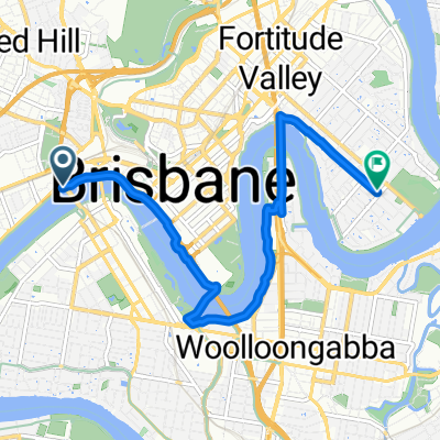
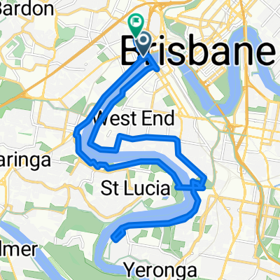
ashgrove route
A cycling route starting in Milton, Queensland, Australia.
Overview
About this route
a nice ride for anyone good one for the kids mostly footpaths and bike paths
- -:--
- Duration
- 11.6 km
- Distance
- 80 m
- Ascent
- 79 m
- Descent
- ---
- Avg. speed
- ---
- Max. altitude
Route quality
Waytypes & surfaces along the route
Waytypes
Cycleway
6.8 km
(59 %)
Quiet road
3.2 km
(28 %)
Surfaces
Paved
10.2 km
(88 %)
Concrete
5.3 km
(46 %)
Asphalt
3.7 km
(32 %)
Continue with Bikemap
Use, edit, or download this cycling route
You would like to ride ashgrove route or customize it for your own trip? Here is what you can do with this Bikemap route:
Free features
- Save this route as favorite or in collections
- Copy & plan your own version of this route
- Sync your route with Garmin or Wahoo
Premium features
Free trial for 3 days, or one-time payment. More about Bikemap Premium.
- Navigate this route on iOS & Android
- Export a GPX / KML file of this route
- Create your custom printout (try it for free)
- Download this route for offline navigation
Discover more Premium features.
Get Bikemap PremiumFrom our community
Other popular routes starting in Milton
 Bicentennial Bikeway, Toowong to Macquarie St, St Lucia
- Distance
- 3.6 km
- Ascent
- 45 m
- Descent
- 45 m
- Location
- Milton, Queensland, Australia
 Bicentennial Bikeway, Toowong to 10 Landsborough Terrace, Toowong
- Distance
- 10.2 km
- Ascent
- 0 m
- Descent
- 7 m
- Location
- Milton, Queensland, Australia
 river loop
- Distance
- 31 km
- Ascent
- 183 m
- Descent
- 180 m
- Location
- Milton, Queensland, Australia
 bike tour from Milton to Hendra
- Distance
- 13.9 km
- Ascent
- 182 m
- Descent
- 174 m
- Location
- Milton, Queensland, Australia
 Toowong to Clontarf
- Distance
- 42.6 km
- Ascent
- 207 m
- Descent
- 223 m
- Location
- Milton, Queensland, Australia
 Mt Coot-tha foothills plus quick river loop
- Distance
- 12.7 km
- Ascent
- 172 m
- Descent
- 172 m
- Location
- Milton, Queensland, Australia
 Milton to New Farm Jodey's Cafe
- Distance
- 8.2 km
- Ascent
- 75 m
- Descent
- 79 m
- Location
- Milton, Queensland, Australia
 Brisbane Corso River Loop
- Distance
- 22.3 km
- Ascent
- 134 m
- Descent
- 181 m
- Location
- Milton, Queensland, Australia
Open it in the app