

Siódma duża trasa 2013
A cycling route starting in Łańcut, Subcarpathian Voivodeship, Poland.
Overview
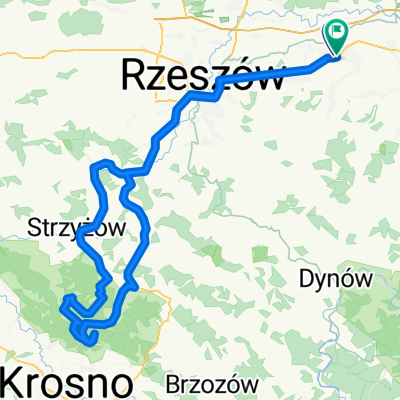
About this route
The route is mostly over hills. A point over 500m high is beyond Gwoźnica Górna.
- -:--
- Duration
- 104.5 km
- Distance
- 745 m
- Ascent
- 740 m
- Descent
- ---
- Avg. speed
- ---
- Max. altitude
Route quality
Waytypes & surfaces along the route
Waytypes
Road
45 km
(43 %)
Quiet road
25.1 km
(24 %)
Surfaces
Paved
87.8 km
(84 %)
Unpaved
6.3 km
(6 %)
Asphalt
85.7 km
(82 %)
Unpaved (undefined)
3.1 km
(3 %)
Route highlights
Points of interest along the route
Point of interest after 50.7 km
Najwyższy punkt trasy - ponad 500m
Continue with Bikemap
Use, edit, or download this cycling route
You would like to ride Siódma duża trasa 2013 or customize it for your own trip? Here is what you can do with this Bikemap route:
Free features
- Save this route as favorite or in collections
- Copy & plan your own version of this route
- Split it into stages to create a multi-day tour
- Sync your route with Garmin or Wahoo
Premium features
Free trial for 3 days, or one-time payment. More about Bikemap Premium.
- Navigate this route on iOS & Android
- Export a GPX / KML file of this route
- Create your custom printout (try it for free)
- Download this route for offline navigation
Discover more Premium features.
Get Bikemap PremiumFrom our community
Other popular routes starting in Łańcut
 Siódma duża trasa 2013
- Distance
- 104.5 km
- Ascent
- 745 m
- Descent
- 740 m
- Location
- Łańcut, Subcarpathian Voivodeship, Poland
 I Łańcucki Maraton Kolarski MTB
- Distance
- 44.4 km
- Ascent
- 449 m
- Descent
- 450 m
- Location
- Łańcut, Subcarpathian Voivodeship, Poland
 MTB Łańcut 2018
- Distance
- 53.2 km
- Ascent
- 691 m
- Descent
- 691 m
- Location
- Łańcut, Subcarpathian Voivodeship, Poland
 Sucha Góra - planowana
- Distance
- 142.2 km
- Ascent
- 678 m
- Descent
- 687 m
- Location
- Łańcut, Subcarpathian Voivodeship, Poland
 Bieszczady 2012 - Majówka
- Distance
- 333.4 km
- Ascent
- 1,504 m
- Descent
- 1,536 m
- Location
- Łańcut, Subcarpathian Voivodeship, Poland
 bonnesoiree07072015
- Distance
- 57.1 km
- Ascent
- 658 m
- Descent
- 655 m
- Location
- Łańcut, Subcarpathian Voivodeship, Poland
 Kraczkowa Krasne s19 a4 Łańcut 15 IX 2013
- Distance
- 43.2 km
- Ascent
- 114 m
- Descent
- 115 m
- Location
- Łańcut, Subcarpathian Voivodeship, Poland
 Łańcut do Ks J Forysiewicza, Głogów Małopolski
- Distance
- 32.5 km
- Ascent
- 148 m
- Descent
- 158 m
- Location
- Łańcut, Subcarpathian Voivodeship, Poland
Open it in the app