

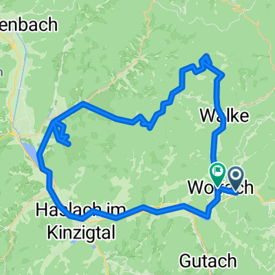
Wolfach - Halbmeil - Moosenmaettle - Hornberg
A cycling route starting in Wolfach, Baden-Wurttemberg, Germany.
Overview
About this route
Tour über Halbmeil, Moosenmättle, Fohrenbühl, Oberreichenbach, Hornberg, Gutach und Hausach zrück nach Wolfach
(cloned from route 2267369)
- -:--
- Duration
- 52 km
- Distance
- 965 m
- Ascent
- 973 m
- Descent
- ---
- Avg. speed
- ---
- Max. altitude
Continue with Bikemap
Use, edit, or download this cycling route
You would like to ride Wolfach - Halbmeil - Moosenmaettle - Hornberg or customize it for your own trip? Here is what you can do with this Bikemap route:
Free features
- Save this route as favorite or in collections
- Copy & plan your own version of this route
- Sync your route with Garmin or Wahoo
Premium features
Free trial for 3 days, or one-time payment. More about Bikemap Premium.
- Navigate this route on iOS & Android
- Export a GPX / KML file of this route
- Create your custom printout (try it for free)
- Download this route for offline navigation
Discover more Premium features.
Get Bikemap PremiumFrom our community
Other popular routes starting in Wolfach
 Wolfach Neckar Glatt
- Distance
- 103.5 km
- Ascent
- 1,940 m
- Descent
- 1,887 m
- Location
- Wolfach, Baden-Wurttemberg, Germany
 Vor Schiltersbach, Wolfach nach Vor Schiltersbach, Wolfach
- Distance
- 45.4 km
- Ascent
- 841 m
- Descent
- 842 m
- Location
- Wolfach, Baden-Wurttemberg, Germany
 Recovered Route
- Distance
- 62.5 km
- Ascent
- 917 m
- Descent
- 910 m
- Location
- Wolfach, Baden-Wurttemberg, Germany
 Teisenkopf
- Distance
- 31.5 km
- Ascent
- 1,006 m
- Descent
- 1,002 m
- Location
- Wolfach, Baden-Wurttemberg, Germany
 Wolfach
- Distance
- 34.8 km
- Ascent
- 822 m
- Descent
- 821 m
- Location
- Wolfach, Baden-Wurttemberg, Germany
 Wolfach - Biberach - Bad Peterstal - Wolfach
- Distance
- 69.4 km
- Ascent
- 889 m
- Descent
- 889 m
- Location
- Wolfach, Baden-Wurttemberg, Germany
 Wolfach - Halbmeil - Moosenmaettle - Hornberg
- Distance
- 52 km
- Ascent
- 965 m
- Descent
- 973 m
- Location
- Wolfach, Baden-Wurttemberg, Germany
 Vor Schiltersbach, Wolfach nach Vor Schiltersbach, Wolfach
- Distance
- 28.2 km
- Ascent
- 268 m
- Descent
- 260 m
- Location
- Wolfach, Baden-Wurttemberg, Germany
Open it in the app