

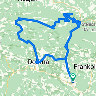
Vojnik - Vače
A cycling route starting in Vojnik, Vojnik, Slovenia.
Overview
About this route
Route from Vojnik to Vač on asphalted roads.
- -:--
- Duration
- 58.1 km
- Distance
- 586 m
- Ascent
- 327 m
- Descent
- ---
- Avg. speed
- ---
- Max. altitude
Route quality
Waytypes & surfaces along the route
Waytypes
Road
2.9 km
(5 %)
Pedestrian area
2.3 km
(4 %)
Surfaces
Paved
20.9 km
(36 %)
Unpaved
0.6 km
(1 %)
Asphalt
20.9 km
(36 %)
Ground
0.6 km
(1 %)
Undefined
36.6 km
(63 %)
Continue with Bikemap
Use, edit, or download this cycling route
You would like to ride Vojnik - Vače or customize it for your own trip? Here is what you can do with this Bikemap route:
Free features
- Save this route as favorite or in collections
- Copy & plan your own version of this route
- Sync your route with Garmin or Wahoo
Premium features
Free trial for 3 days, or one-time payment. More about Bikemap Premium.
- Navigate this route on iOS & Android
- Export a GPX / KML file of this route
- Create your custom printout (try it for free)
- Download this route for offline navigation
Discover more Premium features.
Get Bikemap PremiumFrom our community
Other popular routes starting in Vojnik
 Testna tura
- Distance
- 23.7 km
- Ascent
- 405 m
- Descent
- 372 m
- Location
- Vojnik, Vojnik, Slovenia
 Žička Kartuzija - Vojnik
- Distance
- 32 km
- Ascent
- 504 m
- Descent
- 502 m
- Location
- Vojnik, Vojnik, Slovenia
 Frankolovo, Frankolovo nach Nad Tovarno, Prebold
- Distance
- 29.9 km
- Ascent
- 185 m
- Descent
- 213 m
- Location
- Vojnik, Vojnik, Slovenia
 Paški Kozjak
- Distance
- 65.7 km
- Ascent
- 2,456 m
- Descent
- 2,455 m
- Location
- Vojnik, Vojnik, Slovenia
 Športni dan - kolesarjenje
- Distance
- 29.7 km
- Ascent
- 393 m
- Descent
- 403 m
- Location
- Vojnik, Vojnik, Slovenia
 Šmartno v Rožni dolini - Velenje - Sleme
- Distance
- 42.8 km
- Ascent
- 1,521 m
- Descent
- 776 m
- Location
- Vojnik, Vojnik, Slovenia
 Sommer 2023 SL-IT
- Distance
- 466.4 km
- Ascent
- 6,557 m
- Descent
- 5,828 m
- Location
- Vojnik, Vojnik, Slovenia
 Pot na Dobrotin 13 to Lokarje 6a
- Distance
- 14.5 km
- Ascent
- 271 m
- Descent
- 280 m
- Location
- Vojnik, Vojnik, Slovenia
Open it in the app