

Ballade pour Lise...
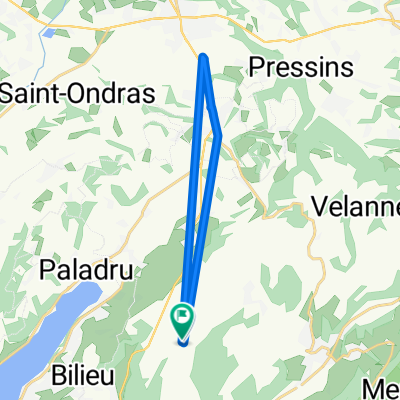
A cycling route starting in Montferrat, Auvergne-Rhône-Alpes, France.
Overview
About this route
Easy ride on asphalt
- -:--
- Duration
- 21.4 km
- Distance
- 264 m
- Ascent
- 273 m
- Descent
- ---
- Avg. speed
- ---
- Max. altitude
Route quality
Waytypes & surfaces along the route
Waytypes
Quiet road
6.4 km
(30 %)
Road
3.2 km
(15 %)
Surfaces
Paved
13 km
(61 %)
Asphalt
13 km
(61 %)
Undefined
8.3 km
(39 %)
Continue with Bikemap
Use, edit, or download this cycling route
You would like to ride Ballade pour Lise... or customize it for your own trip? Here is what you can do with this Bikemap route:
Free features
- Save this route as favorite or in collections
- Copy & plan your own version of this route
- Sync your route with Garmin or Wahoo
Premium features
Free trial for 3 days, or one-time payment. More about Bikemap Premium.
- Navigate this route on iOS & Android
- Export a GPX / KML file of this route
- Create your custom printout (try it for free)
- Download this route for offline navigation
Discover more Premium features.
Get Bikemap PremiumFrom our community
Other popular routes starting in Montferrat
 De Route des Rivoires à Route des Rivoires
- Distance
- 16.2 km
- Ascent
- 46 m
- Descent
- 133 m
- Location
- Montferrat, Auvergne-Rhône-Alpes, France
 Ballade pour Lise...
- Distance
- 21.4 km
- Ascent
- 264 m
- Descent
- 273 m
- Location
- Montferrat, Auvergne-Rhône-Alpes, France
 paladru contre la montre
- Distance
- 14.2 km
- Ascent
- 178 m
- Descent
- 176 m
- Location
- Montferrat, Auvergne-Rhône-Alpes, France
 chaud oui
- Distance
- 42.5 km
- Ascent
- 739 m
- Descent
- 1,185 m
- Location
- Montferrat, Auvergne-Rhône-Alpes, France
 LAGO PALADRU - GRENOBLE-VALENCE
- Distance
- 169.5 km
- Ascent
- 345 m
- Descent
- 726 m
- Location
- Montferrat, Auvergne-Rhône-Alpes, France
 Etappe 29
- Distance
- 30.6 km
- Ascent
- 161 m
- Descent
- 517 m
- Location
- Montferrat, Auvergne-Rhône-Alpes, France
 De 113 Chemin des Vignes, Montferrat à 110 Route Nationale 75, Charancieu
- Distance
- 4.4 km
- Ascent
- 29 m
- Descent
- 153 m
- Location
- Montferrat, Auvergne-Rhône-Alpes, France
 36 Impasse Champ Dolivet 2, Paladru à 39 Rue Saint-Michel, Paladru
- Distance
- 1.7 km
- Ascent
- 9 m
- Descent
- 25 m
- Location
- Montferrat, Auvergne-Rhône-Alpes, France
Open it in the app