

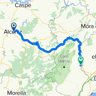
Etapa Acabando en San Cristobal
A cycling route starting in Alcañiz, Aragon, Spain.
Overview
About this route
Departure from Motorland, arrival at San Cristobal
- -:--
- Duration
- 180.1 km
- Distance
- 2,299 m
- Ascent
- 1,233 m
- Descent
- ---
- Avg. speed
- ---
- Max. altitude

Route quality
Waytypes & surfaces along the route
Waytypes
Cycleway
30.6 km
(17 %)
Road
27 km
(15 %)
Surfaces
Paved
30.6 km
(17 %)
Unpaved
16.2 km
(9 %)
Asphalt
30.6 km
(17 %)
Ground
9 km
(5 %)
Continue with Bikemap
Use, edit, or download this cycling route
You would like to ride Etapa Acabando en San Cristobal or customize it for your own trip? Here is what you can do with this Bikemap route:
Free features
- Save this route as favorite or in collections
- Copy & plan your own version of this route
- Split it into stages to create a multi-day tour
- Sync your route with Garmin or Wahoo
Premium features
Free trial for 3 days, or one-time payment. More about Bikemap Premium.
- Navigate this route on iOS & Android
- Export a GPX / KML file of this route
- Create your custom printout (try it for free)
- Download this route for offline navigation
Discover more Premium features.
Get Bikemap PremiumFrom our community
Other popular routes starting in Alcañiz
 Vall de Zafan
- Distance
- 93.9 km
- Ascent
- 1,966 m
- Descent
- 2,265 m
- Location
- Alcañiz, Aragon, Spain
 Alcañiz - Valderrobres - Pto Torremiro - Pto Rafales - Alcañiz
- Distance
- 155.2 km
- Ascent
- 1,651 m
- Descent
- 1,650 m
- Location
- Alcañiz, Aragon, Spain
 Alcañiz - Almuerzo en La Codoñera
- Distance
- 58.6 km
- Ascent
- 465 m
- Descent
- 464 m
- Location
- Alcañiz, Aragon, Spain
 Vía Verde Alcañiz - Tortosa
- Distance
- 107 km
- Ascent
- 583 m
- Descent
- 913 m
- Location
- Alcañiz, Aragon, Spain
 200212: Alcaniz - Teruel
- Distance
- 152.7 km
- Ascent
- 1,833 m
- Descent
- 1,264 m
- Location
- Alcañiz, Aragon, Spain
 Vía Verde Alcañiz - Tortosa
- Distance
- 100.6 km
- Ascent
- 579 m
- Descent
- 899 m
- Location
- Alcañiz, Aragon, Spain
 Alcañiz - Almuerzo en Calanda
- Distance
- 55.2 km
- Ascent
- 364 m
- Descent
- 363 m
- Location
- Alcañiz, Aragon, Spain
 Etapa Acabando en San Cristobal
- Distance
- 180.1 km
- Ascent
- 2,299 m
- Descent
- 1,233 m
- Location
- Alcañiz, Aragon, Spain
Open it in the app