Allgäutour
A cycling route starting in Vogt, Baden-Württemberg, Germany.
Overview
About this route
Eine wunderschöne Tour von Vogt, dem "Tor zum Allgäu" ins Allgäu nach Buchenberg und über Grossholzleute, Isny und Kisslegg zurück nach Vogt.
- -:--
- Duration
- 113.9 km
- Distance
- 625 m
- Ascent
- 625 m
- Descent
- ---
- Avg. speed
- ---
- Avg. speed
Route quality
Waytypes & surfaces along the route
Waytypes
Quiet road
42.2 km
(37 %)
Road
27.4 km
(24 %)
Surfaces
Paved
80.7 km
(71 %)
Unpaved
6.4 km
(6 %)
Asphalt
80.1 km
(70 %)
Gravel
2.5 km
(2 %)
Continue with Bikemap
Use, edit, or download this cycling route
You would like to ride Allgäutour or customize it for your own trip? Here is what you can do with this Bikemap route:
Free features
- Save this route as favorite or in collections
- Copy & plan your own version of this route
- Sync your route with Garmin or Wahoo
Premium features
Free trial for 3 days, or one-time payment. More about Bikemap Premium.
- Navigate this route on iOS & Android
- Export a GPX / KML file of this route
- Create your custom printout (try it for free)
- Download this route for offline navigation
Discover more Premium features.
Get Bikemap PremiumFrom our community
Other popular routes starting in Vogt
- entspannte Route
- Distance
- 9.7 km
- Ascent
- 468 m
- Descent
- 464 m
- Location
- Vogt, Baden-Württemberg, Germany
- Altdorfer Wald Rundfahrt
- Distance
- 14.1 km
- Ascent
- 225 m
- Descent
- 198 m
- Location
- Vogt, Baden-Württemberg, Germany
- Vogter Runde
- Distance
- 47.2 km
- Ascent
- 1,470 m
- Descent
- 1,468 m
- Location
- Vogt, Baden-Württemberg, Germany
- Gute Radler - Tour Vogt
- Distance
- 122.1 km
- Ascent
- 348 m
- Descent
- 599 m
- Location
- Vogt, Baden-Württemberg, Germany
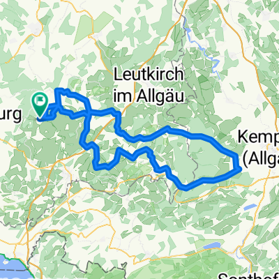
- 24.08.2020 33 Seen-Weiher-Tour
- Distance
- 98 km
- Ascent
- 1,367 m
- Descent
- 1,367 m
- Location
- Vogt, Baden-Württemberg, Germany
- Vogt - Legau - Vogt
- Distance
- 88 km
- Ascent
- 440 m
- Descent
- 439 m
- Location
- Vogt, Baden-Württemberg, Germany
- Pfänderrunde von Vogt
- Distance
- 103.9 km
- Ascent
- 929 m
- Descent
- 929 m
- Location
- Vogt, Baden-Württemberg, Germany
- Grüner Baum-St, Gallen
- Distance
- 79.5 km
- Ascent
- 830 m
- Descent
- 771 m
- Location
- Vogt, Baden-Württemberg, Germany
Open it in the app