

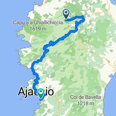
CORSICA 4: Asco - Porticio
A cycling route starting in Calenzana, Corsica, France.
Overview
About this route
Col de Vergio; Col de Sevi, Col de San Bastiano, Col de Listincone, Bocca di Carbinica, Bocca di Pruno
- -:--
- Duration
- 172.4 km
- Distance
- 2,204 m
- Ascent
- 2,835 m
- Descent
- ---
- Avg. speed
- ---
- Max. altitude
Route quality
Waytypes & surfaces along the route
Waytypes
Road
36.2 km
(21 %)
Quiet road
5.2 km
(3 %)
Surfaces
Paved
77.6 km
(45 %)
Asphalt
77.6 km
(45 %)
Undefined
94.8 km
(55 %)
Continue with Bikemap
Use, edit, or download this cycling route
You would like to ride CORSICA 4: Asco - Porticio or customize it for your own trip? Here is what you can do with this Bikemap route:
Free features
- Save this route as favorite or in collections
- Copy & plan your own version of this route
- Split it into stages to create a multi-day tour
- Sync your route with Garmin or Wahoo
Premium features
Free trial for 3 days, or one-time payment. More about Bikemap Premium.
- Navigate this route on iOS & Android
- Export a GPX / KML file of this route
- Create your custom printout (try it for free)
- Download this route for offline navigation
Discover more Premium features.
Get Bikemap PremiumFrom our community
Other popular routes starting in Calenzana
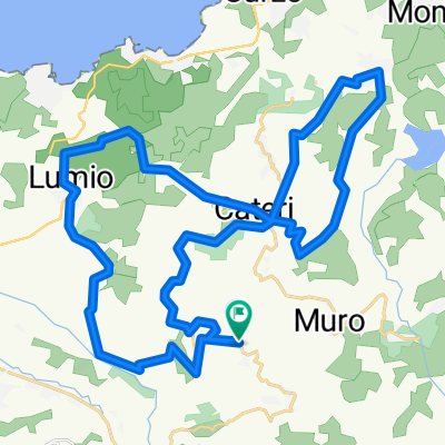
 Korsyka - dzień 4. 100km - podjazdy ok 2000m
- Distance
- 97.8 km
- Ascent
- 1,479 m
- Descent
- 1,520 m
- Location
- Calenzana, Corsica, France
 CORSICA 4: Asco - Porticio
- Distance
- 172.4 km
- Ascent
- 2,204 m
- Descent
- 2,835 m
- Location
- Calenzana, Corsica, France
 2-LUNGHIGNANO-SANTA-REPARATA-LUNGHIGNANO
- Distance
- 41.6 km
- Ascent
- 999 m
- Descent
- 999 m
- Location
- Calenzana, Corsica, France
 Korsyka '13 - dzień 4.
- Distance
- 89.6 km
- Ascent
- 1,100 m
- Descent
- 1,146 m
- Location
- Calenzana, Corsica, France
 Bastia - Haut-Asco
- Distance
- 148.6 km
- Ascent
- 1,942 m
- Descent
- 3,385 m
- Location
- Calenzana, Corsica, France
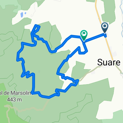 COL DE MARSOLINU
- Distance
- 13 km
- Ascent
- 483 m
- Descent
- 490 m
- Location
- Calenzana, Corsica, France
 Korsika Le Fango - Galeria - Calvi
- Distance
- 41.3 km
- Ascent
- 347 m
- Descent
- 354 m
- Location
- Calenzana, Corsica, France
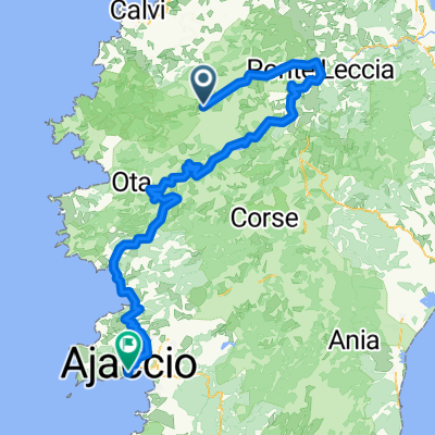 Ajaccio - Haut Asco
- Distance
- 178.6 km
- Ascent
- 2,220 m
- Descent
- 3,688 m
- Location
- Calenzana, Corsica, France
Open it in the app