

Schiem-a-no.de: Tour2/Pottenstein – Weiße Marter
A cycling route starting in Pottenstein, Bavaria, Germany.
Overview
About this route
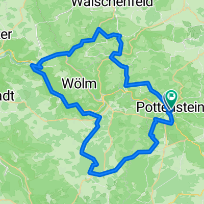
<font face="Arial"><font face="Arial">Charakter: Eine weich in die landschaft geschmiegte Tour mit schönen Aussichten, kurze fahrtechnische Abfahrten wechseln mit moderaten Anstiegen<br /> 39 km, 1000 Hm, 3,5 – 4,5 h<br /> Kondition: mittel Fahrtechnik. Mittel<br /> Route: Pottenstein – Höhenweg Ri. Gößweinstein – Abfahrt in die Bärenschlucht - Haßlach Hohe Leite – Brünnberg – Neumühle (Anschluß Tour 4) – Oberailsfeld – Weiße Marter – Moschendorf – Schottersmühle – Tüchersfeld – Haßlach – Haselbrunn – Pottenstein<br /> Beschreibung: Zu Beginn der einzige knackige Anstieg zur Kreuzkapelle (schöner Blick über Pottenstein), vom einem schönen Wiesentrail geht’s rechts ab in die Bärenschlucht (Campingplatz). leicht bergan, anfangs Asphalt,am Ende schöner Pfad zur Hohen Leite. Herrlicher Ausblick über die Höhen der Fränkischen Schweiz. Botanikfreunde aufgepasst, wilde Orchideen. Von nun an wechseln sich schöne Trailabschnitte mit Waldwegen über Oberailsfeld und der Weißen Marter nach Tüchersfeld ab. Vom größten Kleinkunstdenkmal der Region, der Weißen Marter, erblickt man die Türme der Basilika in Gößweinstein. Im Wiesenttal flussabwärts nach Behringesmühle. In Tüchersfeld angelangt, lohnt sich der Abstecher ins Fränkische-Schweiz-Museum. Den Besucher erwarten wechselnde Themenausstellungen und historische Einblicke in das ländliche Leben der Region. Der kurze Stopp am Kängurugehege (Wallabies) vor Haselbrunn, rundet die chillige Tour, bevor wir flowig gen Pottenstein rollen, ab. </font></font>
- -:--
- Duration
- 39.1 km
- Distance
- 618 m
- Ascent
- 620 m
- Descent
- ---
- Avg. speed
- ---
- Max. altitude

Route quality
Waytypes & surfaces along the route
Waytypes
Track
15.1 km
(39 %)
Path
11.2 km
(29 %)
Surfaces
Paved
6.8 km
(17 %)
Unpaved
21.1 km
(54 %)
Ground
10 km
(25 %)
Gravel
7.7 km
(20 %)
Continue with Bikemap
Use, edit, or download this cycling route
You would like to ride Schiem-a-no.de: Tour2/Pottenstein – Weiße Marter or customize it for your own trip? Here is what you can do with this Bikemap route:
Free features
- Save this route as favorite or in collections
- Copy & plan your own version of this route
- Sync your route with Garmin or Wahoo
Premium features
Free trial for 3 days, or one-time payment. More about Bikemap Premium.
- Navigate this route on iOS & Android
- Export a GPX / KML file of this route
- Create your custom printout (try it for free)
- Download this route for offline navigation
Discover more Premium features.
Get Bikemap PremiumFrom our community
Other popular routes starting in Pottenstein
 KleinePot Pottenstein
- Distance
- 18.1 km
- Ascent
- 352 m
- Descent
- 350 m
- Location
- Pottenstein, Bavaria, Germany
 Pottenstein -> Erlangen (Rücktour) - Samstag 29.08.09
- Distance
- 53.3 km
- Ascent
- 505 m
- Descent
- 682 m
- Location
- Pottenstein, Bavaria, Germany
 Pottenstein-Waldcafe-Aussichtsturm
- Distance
- 7.3 km
- Ascent
- 206 m
- Descent
- 209 m
- Location
- Pottenstein, Bavaria, Germany
 Vorschlag 2
- Distance
- 46.1 km
- Ascent
- 642 m
- Descent
- 644 m
- Location
- Pottenstein, Bavaria, Germany
 Unterwegs_Püttlachtal
- Distance
- 27.4 km
- Ascent
- 562 m
- Descent
- 563 m
- Location
- Pottenstein, Bavaria, Germany
 Dolomitsteilwände, Grotten und Höhlen
- Distance
- 15.9 km
- Ascent
- 341 m
- Descent
- 338 m
- Location
- Pottenstein, Bavaria, Germany
 Pottenstein mtb
- Distance
- 36.8 km
- Ascent
- 684 m
- Descent
- 692 m
- Location
- Pottenstein, Bavaria, Germany
 Schiem-a-no.de: Tour2/Pottenstein – Weiße Marter
- Distance
- 39.1 km
- Ascent
- 618 m
- Descent
- 620 m
- Location
- Pottenstein, Bavaria, Germany
Open it in the app