

HB-Zürichsee-Affoltern
A cycling route starting in Zürich (Kreis 1) / Lindenhof, Canton of Zurich, Switzerland.
Overview
About this route
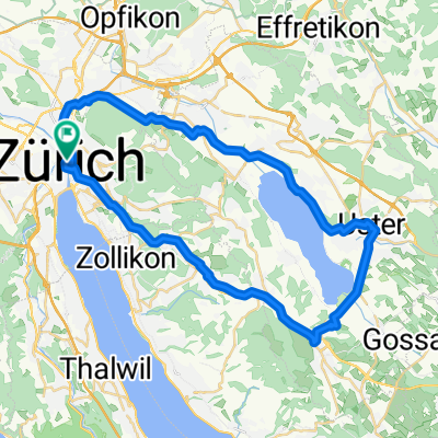
From Zurich Mainstain to the Bellevue, around the whole lake of Zurich via Rapperswil to Schmerikon to Wädenswil and back to Zurich. Final destination is Affoltern, ZH.
- -:--
- Duration
- 103.7 km
- Distance
- 243 m
- Ascent
- 201 m
- Descent
- ---
- Avg. speed
- ---
- Avg. speed
Route quality
Waytypes & surfaces along the route
Waytypes
Busy road
71.3 km
(69 %)
Quiet road
11.7 km
(11 %)
Surfaces
Paved
91.6 km
(88 %)
Unpaved
0.5 km
(<1 %)
Asphalt
91 km
(88 %)
Gravel
0.2 km
(<1 %)
Continue with Bikemap
Use, edit, or download this cycling route
You would like to ride HB-Zürichsee-Affoltern or customize it for your own trip? Here is what you can do with this Bikemap route:
Free features
- Save this route as favorite or in collections
- Copy & plan your own version of this route
- Split it into stages to create a multi-day tour
- Sync your route with Garmin or Wahoo
Premium features
Free trial for 3 days, or one-time payment. More about Bikemap Premium.
- Navigate this route on iOS & Android
- Export a GPX / KML file of this route
- Create your custom printout (try it for free)
- Download this route for offline navigation
Discover more Premium features.
Get Bikemap PremiumFrom our community
Other popular routes starting in Zürich (Kreis 1) / Lindenhof
 Cyklodovolená 2017 1.den
- Distance
- 91.7 km
- Ascent
- 1,407 m
- Descent
- 785 m
- Location
- Zürich (Kreis 1) / Lindenhof, Canton of Zurich, Switzerland
 Uster - Greifensee
- Distance
- 42.6 km
- Ascent
- 370 m
- Descent
- 370 m
- Location
- Zürich (Kreis 1) / Lindenhof, Canton of Zurich, Switzerland
 HB-Zürichsee-Affoltern
- Distance
- 103.7 km
- Ascent
- 243 m
- Descent
- 201 m
- Location
- Zürich (Kreis 1) / Lindenhof, Canton of Zurich, Switzerland
 penzello
- Distance
- 100.9 km
- Ascent
- 1,458 m
- Descent
- 1,076 m
- Location
- Zürich (Kreis 1) / Lindenhof, Canton of Zurich, Switzerland
 Drei Voralpenpässe, Albispass, Ratenpass, Sattelegg
- Distance
- 129.6 km
- Ascent
- 1,792 m
- Descent
- 1,784 m
- Location
- Zürich (Kreis 1) / Lindenhof, Canton of Zurich, Switzerland
 Elvira Zürich-Luzern-Bern-Biel
- Distance
- 243 km
- Ascent
- 1,092 m
- Descent
- 1,060 m
- Location
- Zürich (Kreis 1) / Lindenhof, Canton of Zurich, Switzerland
 Verano 2023
- Distance
- 831.2 km
- Ascent
- 6,209 m
- Descent
- 6,619 m
- Location
- Zürich (Kreis 1) / Lindenhof, Canton of Zurich, Switzerland
 Zürich-Vaduz-Chur-St.Moritz-Chiavenna-Como-Milan-Bergamo
- Distance
- 488.4 km
- Ascent
- 2,852 m
- Descent
- 3,012 m
- Location
- Zürich (Kreis 1) / Lindenhof, Canton of Zurich, Switzerland
Open it in the app