Przemyśl-Prałkowce-Brylińce-Krasiczyn-Przemyśl
A cycling route starting in Przemyśl, Subcarpathian Voivodeship, Poland.
Overview
About this route
Trasa łatwa , dwa strome podjazdy w Prałkowcach. Mój czas przejazdu 2 godz (połowa w ulewnym deszczu :) ).
- -:--
- Duration
- 41.2 km
- Distance
- 487 m
- Ascent
- 495 m
- Descent
- ---
- Avg. speed
- ---
- Avg. speed
Route quality
Waytypes & surfaces along the route
Waytypes
Road
17.6 km
(43 %)
Busy road
14.4 km
(35 %)
Surfaces
Paved
27.1 km
(66 %)
Unpaved
3.1 km
(8 %)
Asphalt
26.9 km
(65 %)
Gravel
3.1 km
(8 %)
Continue with Bikemap
Use, edit, or download this cycling route
You would like to ride Przemyśl-Prałkowce-Brylińce-Krasiczyn-Przemyśl or customize it for your own trip? Here is what you can do with this Bikemap route:
Free features
- Save this route as favorite or in collections
- Copy & plan your own version of this route
- Sync your route with Garmin or Wahoo
Premium features
Free trial for 3 days, or one-time payment. More about Bikemap Premium.
- Navigate this route on iOS & Android
- Export a GPX / KML file of this route
- Create your custom printout (try it for free)
- Download this route for offline navigation
Discover more Premium features.
Get Bikemap PremiumFrom our community
Other popular routes starting in Przemyśl
- Przemyśl-Kalników-Korczowa-Radymno-Przemyśl
- Distance
- 81.1 km
- Ascent
- 197 m
- Descent
- 197 m
- Location
- Przemyśl, Subcarpathian Voivodeship, Poland
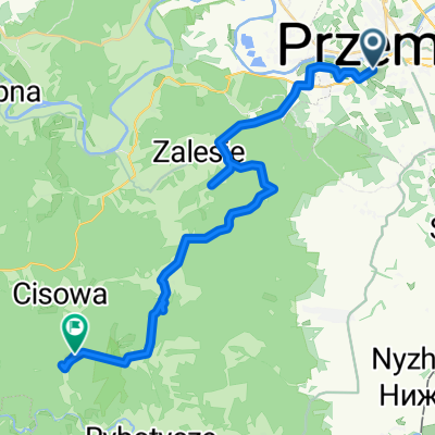
- Ignacego Prądzyńskiego 21, Przemyśl do Gen. Prądzyńskiego 23, Przemyśl
- Distance
- 21.3 km
- Ascent
- 657 m
- Descent
- 653 m
- Location
- Przemyśl, Subcarpathian Voivodeship, Poland
- MEGA Cyklokarpaty.pl Przemyśl 2016
- Distance
- 43.7 km
- Ascent
- 890 m
- Descent
- 890 m
- Location
- Przemyśl, Subcarpathian Voivodeship, Poland
- Gen. Prądzyńskiego 26, Przemyśl do Marcina Bielskiego 66, Przemyśl
- Distance
- 34.7 km
- Ascent
- 1,608 m
- Descent
- 1,632 m
- Location
- Przemyśl, Subcarpathian Voivodeship, Poland
- Dookoła Polski 1dzień (Przemyśl-Nowa Wieś)
- Distance
- 32.4 km
- Ascent
- 465 m
- Descent
- 404 m
- Location
- Przemyśl, Subcarpathian Voivodeship, Poland
- Przemyśl-Lecka-Bachórz
- Distance
- 82.4 km
- Ascent
- 531 m
- Descent
- 563 m
- Location
- Przemyśl, Subcarpathian Voivodeship, Poland
- Przemyśl (Gmina) Bieg
- Distance
- 27.8 km
- Ascent
- 581 m
- Descent
- 582 m
- Location
- Przemyśl, Subcarpathian Voivodeship, Poland
- Przemysl - wisan
- Distance
- 95.2 km
- Ascent
- 1,970 m
- Descent
- 1,692 m
- Location
- Przemyśl, Subcarpathian Voivodeship, Poland