

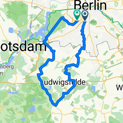
Südkreuz -> Selchow -> Mittenwalde -> Mauer von Telz -> Ludwigsfelde -> Neubeeren -> Stahnsdorf -> Wannsee -> Bundesplatz
A cycling route starting in Schöneberg, State of Berlin, Germany.
Overview
About this route
Ride on quiet streets or good accompanying bike paths. A short uncomfortable section in Stahnsdorf (L76), but it is only a few hundred meters. Break option in Mittenwalde (Osteria nella Casa Tedesca)
- -:--
- Duration
- 103.8 km
- Distance
- 133 m
- Ascent
- 129 m
- Descent
- ---
- Avg. speed
- ---
- Max. altitude

Route quality
Waytypes & surfaces along the route
Waytypes
Path
32.2 km
(31 %)
Quiet road
28 km
(27 %)
Surfaces
Paved
96.5 km
(93 %)
Unpaved
1 km
(1 %)
Asphalt
95.5 km
(92 %)
Concrete
1 km
(1 %)
Continue with Bikemap
Use, edit, or download this cycling route
You would like to ride Südkreuz -> Selchow -> Mittenwalde -> Mauer von Telz -> Ludwigsfelde -> Neubeeren -> Stahnsdorf -> Wannsee -> Bundesplatz or customize it for your own trip? Here is what you can do with this Bikemap route:
Free features
- Save this route as favorite or in collections
- Copy & plan your own version of this route
- Split it into stages to create a multi-day tour
- Sync your route with Garmin or Wahoo
Premium features
Free trial for 3 days, or one-time payment. More about Bikemap Premium.
- Navigate this route on iOS & Android
- Export a GPX / KML file of this route
- Create your custom printout (try it for free)
- Download this route for offline navigation
Discover more Premium features.
Get Bikemap PremiumFrom our community
Other popular routes starting in Schöneberg
 Südkreuz - THF - SXF - Groß Schulzendorf - Genshagen - Siethen - Gröben - Drewitz - Wannsee - Auerbachtunnel
- Distance
- 92.9 km
- Ascent
- 146 m
- Descent
- 137 m
- Location
- Schöneberg, State of Berlin, Germany
 42. Iduna-RTF "Berlin Total"
- Distance
- 110 km
- Ascent
- 84 m
- Descent
- 84 m
- Location
- Schöneberg, State of Berlin, Germany
 Südkreuz -> Selchow -> Mittenwalde -> Mauer von Telz -> Ludwigsfelde -> Neubeeren -> Stahnsdorf -> Wannsee -> Bundesplatz
- Distance
- 103.8 km
- Ascent
- 133 m
- Descent
- 129 m
- Location
- Schöneberg, State of Berlin, Germany
 Südkreuz - Lichtenrade - Jühnsdorf - Christinendorf - Trebbin - Dobbrikow - Michendorf - Caputh - Potsdam - Wannsee - Bundesplatz
- Distance
- 116.7 km
- Ascent
- 145 m
- Descent
- 141 m
- Location
- Schöneberg, State of Berlin, Germany
 Rund um Berlin 2015
- Distance
- 231.7 km
- Ascent
- 180 m
- Descent
- 180 m
- Location
- Schöneberg, State of Berlin, Germany
 Ausflug zum Gleisdreieck
- Distance
- 17.3 km
- Ascent
- 70 m
- Descent
- 66 m
- Location
- Schöneberg, State of Berlin, Germany
 Zur Pizza nach Mittenwalde
- Distance
- 105 km
- Ascent
- 131 m
- Descent
- 127 m
- Location
- Schöneberg, State of Berlin, Germany
 Thyrowrunde
- Distance
- 86.6 km
- Ascent
- 136 m
- Descent
- 129 m
- Location
- Schöneberg, State of Berlin, Germany
Open it in the app