

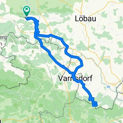
Wilthen-Blausteinhof-Wilthen
A cycling route starting in Wilthen, Saxony, Germany.
Overview
About this route
Start-finish at Haus Bergland in Wilthen (large parking area available)
From Wilthen via Kirschau to the Spree cycle path. Follow it to Eibau (in Ebersbach, an alternative route away from the B road is also possible)
Midway through Eibau, turn left towards Kottmarhäuser-Obercunnersdorf, Blausteinhof, rustic atmosphere, open Fri from 4:00 PM, Sat/Sun from 11:00 AM (information without guarantee - check the website). Via Ober- and Niedercunnersdorf, Dürrhennersdorf, Schönbach, RW Cunewalde, Eulowitz, Rodewitz back to Wilthen
- -:--
- Duration
- 66.1 km
- Distance
- 447 m
- Ascent
- 447 m
- Descent
- ---
- Avg. speed
- ---
- Max. altitude

Route quality
Waytypes & surfaces along the route
Waytypes
Quiet road
25.1 km
(38 %)
Path
13.2 km
(20 %)
Surfaces
Paved
34.4 km
(52 %)
Unpaved
4.6 km
(7 %)
Asphalt
33.7 km
(51 %)
Unpaved (undefined)
2 km
(3 %)
Route highlights
Points of interest along the route
Point of interest after 0.6 km
STart/Ziel - haus Bergland 65km
Point of interest after 35.1 km
Blausteinhof
Continue with Bikemap
Use, edit, or download this cycling route
You would like to ride Wilthen-Blausteinhof-Wilthen or customize it for your own trip? Here is what you can do with this Bikemap route:
Free features
- Save this route as favorite or in collections
- Copy & plan your own version of this route
- Sync your route with Garmin or Wahoo
Premium features
Free trial for 3 days, or one-time payment. More about Bikemap Premium.
- Navigate this route on iOS & Android
- Export a GPX / KML file of this route
- Create your custom printout (try it for free)
- Download this route for offline navigation
Discover more Premium features.
Get Bikemap PremiumFrom our community
Other popular routes starting in Wilthen
 Oppach Bad extended version
- Distance
- 59.6 km
- Ascent
- 320 m
- Descent
- 321 m
- Location
- Wilthen, Saxony, Germany
 Wilthen-Blausteinhof-Wilthen
- Distance
- 66.1 km
- Ascent
- 447 m
- Descent
- 447 m
- Location
- Wilthen, Saxony, Germany
 Butterberg-Tour V2
- Distance
- 48.3 km
- Ascent
- 415 m
- Descent
- 415 m
- Location
- Wilthen, Saxony, Germany
 Wilthen-Oybin Hain Area24-Wilthen
- Distance
- 105.5 km
- Ascent
- 638 m
- Descent
- 638 m
- Location
- Wilthen, Saxony, Germany
 3-Ländertour Wilthen-Jonsdorf-Hradek nad Nisou-Bogatynia-Zittau_Wilthen
- Distance
- 126 km
- Ascent
- 851 m
- Descent
- 851 m
- Location
- Wilthen, Saxony, Germany
 Tilo nur die harten komm in Garten
- Distance
- 133 km
- Ascent
- 1,063 m
- Descent
- 1,067 m
- Location
- Wilthen, Saxony, Germany
 Rund ums Oberland V6
- Distance
- 40.6 km
- Ascent
- 322 m
- Descent
- 322 m
- Location
- Wilthen, Saxony, Germany
 Wilthen-Neustadt-Rugiswalde-Lipova-Wilthen
- Distance
- 59.7 km
- Ascent
- 446 m
- Descent
- 446 m
- Location
- Wilthen, Saxony, Germany
Open it in the app