

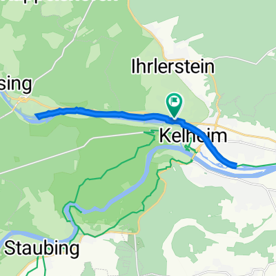
Mit dem MTB im Dreieck Kelheim Altmühl Donau
A cycling route starting in Ihrlerstein, Bavaria, Germany.
Overview
About this route
Round trip Kelheim - Riedenburg - Schambachtal - Hienheim - Weltenburg - Kelheim
- -:--
- Duration
- 51.5 km
- Distance
- 304 m
- Ascent
- 301 m
- Descent
- ---
- Avg. speed
- ---
- Max. altitude
Route quality
Waytypes & surfaces along the route
Waytypes
Track
18.5 km
(36 %)
Quiet road
8.2 km
(16 %)
Surfaces
Paved
27.3 km
(53 %)
Unpaved
14.4 km
(28 %)
Asphalt
25.2 km
(49 %)
Gravel
7.2 km
(14 %)
Continue with Bikemap
Use, edit, or download this cycling route
You would like to ride Mit dem MTB im Dreieck Kelheim Altmühl Donau or customize it for your own trip? Here is what you can do with this Bikemap route:
Free features
- Save this route as favorite or in collections
- Copy & plan your own version of this route
- Sync your route with Garmin or Wahoo
Premium features
Free trial for 3 days, or one-time payment. More about Bikemap Premium.
- Navigate this route on iOS & Android
- Export a GPX / KML file of this route
- Create your custom printout (try it for free)
- Download this route for offline navigation
Discover more Premium features.
Get Bikemap PremiumFrom our community
Other popular routes starting in Ihrlerstein
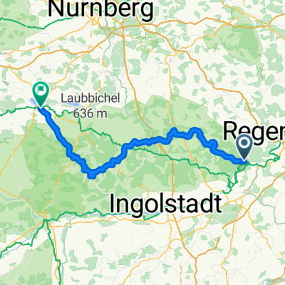
 07b - Kelheim - Regensburg
- Distance
- 42.2 km
- Ascent
- 101 m
- Descent
- 217 m
- Location
- Ihrlerstein, Bavaria, Germany
 24 Std Kehlheim
- Distance
- 17.7 km
- Ascent
- 274 m
- Descent
- 274 m
- Location
- Ihrlerstein, Bavaria, Germany
 Altmühltal Radweg
- Distance
- 137.9 km
- Ascent
- 1,363 m
- Descent
- 1,307 m
- Location
- Ihrlerstein, Bavaria, Germany
 24 Std Kehlheim 17 km Rundkurs
- Distance
- 17.7 km
- Ascent
- 197 m
- Descent
- 197 m
- Location
- Ihrlerstein, Bavaria, Germany
 Riedenburger Straße 60, Kelheim to Riedenburger Straße 62, Kelheim
- Distance
- 14.4 km
- Ascent
- 234 m
- Descent
- 284 m
- Location
- Ihrlerstein, Bavaria, Germany
 Kelheim - Ingolstadt
- Distance
- 69.9 km
- Ascent
- 120 m
- Descent
- 204 m
- Location
- Ihrlerstein, Bavaria, Germany
 Radrunde von Ihrlerstein nach Abensberg
- Distance
- 19.5 km
- Ascent
- 108 m
- Descent
- 200 m
- Location
- Ihrlerstein, Bavaria, Germany
 Mit dem MTB im Dreieck Kelheim Altmühl Donau
- Distance
- 51.5 km
- Ascent
- 304 m
- Descent
- 301 m
- Location
- Ihrlerstein, Bavaria, Germany
Open it in the app