

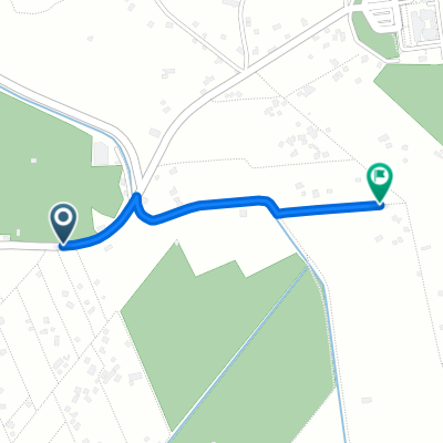
Imzouren-Oued Amlil
A cycling route starting in Imzoûrene, Taza-Al Hoceima-Taounate, Morocco.
Overview
About this route
From North of the Rif Mountains to the begining of the Middle Atlas mountains.
- -:--
- Duration
- 260.6 km
- Distance
- 3,487 m
- Ascent
- 3,264 m
- Descent
- ---
- Avg. speed
- ---
- Max. altitude
Continue with Bikemap
Use, edit, or download this cycling route
You would like to ride Imzouren-Oued Amlil or customize it for your own trip? Here is what you can do with this Bikemap route:
Free features
- Save this route as favorite or in collections
- Copy & plan your own version of this route
- Split it into stages to create a multi-day tour
- Sync your route with Garmin or Wahoo
Premium features
Free trial for 3 days, or one-time payment. More about Bikemap Premium.
- Navigate this route on iOS & Android
- Export a GPX / KML file of this route
- Create your custom printout (try it for free)
- Download this route for offline navigation
Discover more Premium features.
Get Bikemap PremiumFrom our community
Other popular routes starting in Imzoûrene
 Ait Youssef Ou Ali a Ait Youssef Ou Ali
- Distance
- 1.4 km
- Ascent
- 7 m
- Descent
- 3 m
- Location
- Imzoûrene, Taza-Al Hoceima-Taounate, Morocco
 Unnamed Road to Unnamed Road
- Distance
- 0.1 km
- Ascent
- 0 m
- Descent
- 5 m
- Location
- Imzoûrene, Taza-Al Hoceima-Taounate, Morocco
 Route to Rue Nil, Al Hoceima
- Distance
- 18.6 km
- Ascent
- 3 m
- Descent
- 7 m
- Location
- Imzoûrene, Taza-Al Hoceima-Taounate, Morocco
 Vuelta 1. TTT
- Distance
- 15.5 km
- Ascent
- 156 m
- Descent
- 48 m
- Location
- Imzoûrene, Taza-Al Hoceima-Taounate, Morocco
 Imzouren-Oued Amlil
- Distance
- 260.6 km
- Ascent
- 3,487 m
- Descent
- 3,264 m
- Location
- Imzoûrene, Taza-Al Hoceima-Taounate, Morocco
Open it in the app