
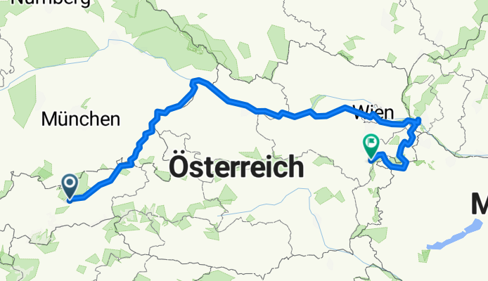
Innsbruck - Forchtenstein
A cycling route starting in Innsbruck, Tyrol, Austria.
Overview
About this route
Radwanderung von Innsbruck nach Forchtenstein, dem Inn und der Donau entlang.
- -:--
- Duration
- 745.9 km
- Distance
- 965 m
- Ascent
- 1,114 m
- Descent
- ---
- Avg. speed
- ---
- Max. altitude

Route quality
Waytypes & surfaces along the route
Waytypes
Quiet road
82 km
(11 %)
Track
67.1 km
(9 %)
Surfaces
Paved
544.5 km
(73 %)
Unpaved
37.3 km
(5 %)
Asphalt
529.6 km
(71 %)
Unpaved (undefined)
14.9 km
(2 %)
Continue with Bikemap
Use, edit, or download this cycling route
You would like to ride Innsbruck - Forchtenstein or customize it for your own trip? Here is what you can do with this Bikemap route:
Free features
- Save this route as favorite or in collections
- Copy & plan your own version of this route
- Split it into stages to create a multi-day tour
- Sync your route with Garmin or Wahoo
Premium features
Free trial for 3 days, or one-time payment. More about Bikemap Premium.
- Navigate this route on iOS & Android
- Export a GPX / KML file of this route
- Create your custom printout (try it for free)
- Download this route for offline navigation
Discover more Premium features.
Get Bikemap PremiumFrom our community
Other popular routes starting in Innsbruck
 Am Roßsprung 1, Innsbruck nach Am Roßsprung 1, Innsbruck
- Distance
- 40 km
- Ascent
- 622 m
- Descent
- 674 m
- Location
- Innsbruck, Tyrol, Austria
 Innsbruck / Zirl / Magdeburger Hüttn / Kranebitten
- Distance
- 52.2 km
- Ascent
- 1,200 m
- Descent
- 1,199 m
- Location
- Innsbruck, Tyrol, Austria
 007
007- Distance
- 87.9 km
- Ascent
- 2,182 m
- Descent
- 2,100 m
- Location
- Innsbruck, Tyrol, Austria
 Innsbruck II
- Distance
- 15.7 km
- Ascent
- 1,386 m
- Descent
- 0 m
- Location
- Innsbruck, Tyrol, Austria
 Innsbruck - Viggarspitze
- Distance
- 16.9 km
- Ascent
- 1,750 m
- Descent
- 61 m
- Location
- Innsbruck, Tyrol, Austria
 IBK - Maria Waldrast - IBK
- Distance
- 62.1 km
- Ascent
- 1,628 m
- Descent
- 1,626 m
- Location
- Innsbruck, Tyrol, Austria
 Nockspitz-Überschreitung
- Distance
- 54 km
- Ascent
- 2,398 m
- Descent
- 2,385 m
- Location
- Innsbruck, Tyrol, Austria
 Stockerhof-Runde
- Distance
- 26.4 km
- Ascent
- 874 m
- Descent
- 875 m
- Location
- Innsbruck, Tyrol, Austria
Open it in the app