

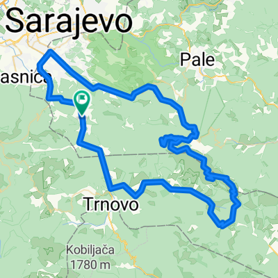
lukomir
A cycling route starting in Gračanica, Federation of Bosnia and Herzegovina, Bosnia and Herzegovina.
Overview
About this route
asdf
- -:--
- Duration
- 18.8 km
- Distance
- 608 m
- Ascent
- 444 m
- Descent
- ---
- Avg. speed
- ---
- Max. altitude

Route quality
Waytypes & surfaces along the route
Waytypes
Quiet road
16.5 km
(88 %)
Track
1.7 km
(9 %)
Surfaces
Paved
2.1 km
(11 %)
Unpaved
14.3 km
(76 %)
Gravel
14.3 km
(76 %)
Asphalt
2.1 km
(11 %)
Undefined
2.4 km
(13 %)
Continue with Bikemap
Use, edit, or download this cycling route
You would like to ride lukomir or customize it for your own trip? Here is what you can do with this Bikemap route:
Free features
- Save this route as favorite or in collections
- Copy & plan your own version of this route
- Sync your route with Garmin or Wahoo
Premium features
Free trial for 3 days, or one-time payment. More about Bikemap Premium.
- Navigate this route on iOS & Android
- Export a GPX / KML file of this route
- Create your custom printout (try it for free)
- Download this route for offline navigation
Discover more Premium features.
Get Bikemap PremiumFrom our community
Other popular routes starting in Gračanica
 Babin Do - Dujmovići - Dejčići - Babin do
- Distance
- 41.7 km
- Ascent
- 931 m
- Descent
- 908 m
- Location
- Gračanica, Federation of Bosnia and Herzegovina, Bosnia and Herzegovina
 Marsal - Sabici - Sinanovici i nazad
- Distance
- 36.9 km
- Ascent
- 828 m
- Descent
- 647 m
- Location
- Gračanica, Federation of Bosnia and Herzegovina, Bosnia and Herzegovina
 Babin Do - Konjic
- Distance
- 43.6 km
- Ascent
- 566 m
- Descent
- 1,565 m
- Location
- Gračanica, Federation of Bosnia and Herzegovina, Bosnia and Herzegovina
 Oko Husremovca
- Distance
- 5.4 km
- Ascent
- 131 m
- Descent
- 145 m
- Location
- Gračanica, Federation of Bosnia and Herzegovina, Bosnia and Herzegovina
 Sabici-Rakitnica-Sinanovici-Sabici CLONED FROM ROUTE 657163
- Distance
- 25.1 km
- Ascent
- 558 m
- Descent
- 542 m
- Location
- Gračanica, Federation of Bosnia and Herzegovina, Bosnia and Herzegovina
 Jahorina
- Distance
- 96.3 km
- Ascent
- 1,733 m
- Descent
- 1,734 m
- Location
- Gračanica, Federation of Bosnia and Herzegovina, Bosnia and Herzegovina
![[Bjelasnica] Babin Do - Lukomir - Babin Do](https://media.bikemap.net/routes/5886988/gallery/thumbs/5387357f-912a-4dc5-9043-a5733d9f1fab.jpg.208x208_q80_crop.jpg) [Bjelasnica] Babin Do - Lukomir - Babin Do
[Bjelasnica] Babin Do - Lukomir - Babin Do- Distance
- 40.5 km
- Ascent
- 879 m
- Descent
- 885 m
- Location
- Gračanica, Federation of Bosnia and Herzegovina, Bosnia and Herzegovina
 Route to Babin do, Sarajevo
- Distance
- 44.2 km
- Ascent
- 1,310 m
- Descent
- 1,326 m
- Location
- Gračanica, Federation of Bosnia and Herzegovina, Bosnia and Herzegovina
Open it in the app