

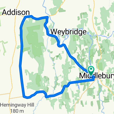
Snake Mountain circumnavigation
A cycling route starting in Middlebury (village), Vermont, United States.
Overview
About this route
Starts at Otter View Park. Lots of dirt roads, but they're well maintained. Your 25's and 28's can handle it.
- -:--
- Duration
- 37.9 km
- Distance
- 367 m
- Ascent
- 367 m
- Descent
- ---
- Avg. speed
- ---
- Max. altitude
Route quality
Waytypes & surfaces along the route
Waytypes
Quiet road
26.5 km
(70 %)
Road
0.4 km
(1 %)
Surfaces
Paved
17.1 km
(45 %)
Unpaved
20.5 km
(54 %)
Gravel
20.5 km
(54 %)
Asphalt
17.1 km
(45 %)
Undefined
0.4 km
(1 %)
Continue with Bikemap
Use, edit, or download this cycling route
You would like to ride Snake Mountain circumnavigation or customize it for your own trip? Here is what you can do with this Bikemap route:
Free features
- Save this route as favorite or in collections
- Copy & plan your own version of this route
- Sync your route with Garmin or Wahoo
Premium features
Free trial for 3 days, or one-time payment. More about Bikemap Premium.
- Navigate this route on iOS & Android
- Export a GPX / KML file of this route
- Create your custom printout (try it for free)
- Download this route for offline navigation
Discover more Premium features.
Get Bikemap PremiumFrom our community
Other popular routes starting in Middlebury (village)
 Snake Mountain circumnavigation
- Distance
- 37.9 km
- Ascent
- 367 m
- Descent
- 367 m
- Location
- Middlebury (village), Vermont, United States
 Middlebury/Lac Dunmore/Brandon
- Distance
- 76.6 km
- Ascent
- 309 m
- Descent
- 314 m
- Location
- Middlebury (village), Vermont, United States
 Classic Loop
- Distance
- 37 km
- Ascent
- 304 m
- Descent
- 304 m
- Location
- Middlebury (village), Vermont, United States
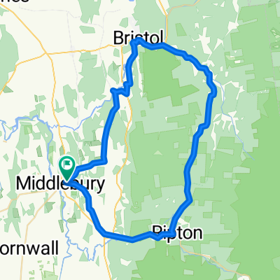 bristol linc rip
- Distance
- 56.6 km
- Ascent
- 622 m
- Descent
- 623 m
- Location
- Middlebury (village), Vermont, United States
 Gap to Gap
- Distance
- 88.6 km
- Ascent
- 1,024 m
- Descent
- 1,025 m
- Location
- Middlebury (village), Vermont, United States
 munger-lower notch loop
- Distance
- 28 km
- Ascent
- 265 m
- Descent
- 269 m
- Location
- Middlebury (village), Vermont, United States
 Swamp-Jersey-Vergennes
- Distance
- 88.1 km
- Ascent
- 405 m
- Descent
- 402 m
- Location
- Middlebury (village), Vermont, United States
 Dan & Rich Birthday Brap
- Distance
- 127.5 km
- Ascent
- 1,148 m
- Descent
- 1,156 m
- Location
- Middlebury (village), Vermont, United States
Open it in the app