

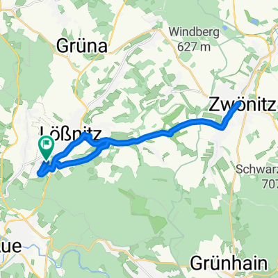
Lößnitz -> Greifenbachstauweiher
A cycling route starting in Lößnitz, Saxony, Germany.
Overview
About this route
Nice beginner cycling tour of 20 km with country roads, village, and forest sections.
The forest section, Zwönitz-Geyrischer Teich, was heavily eroded after rain and also very churned up by motocross riders. We rode this section with mountain bikes and had to navigate ruts and puddles.
- -:--
- Duration
- 20.7 km
- Distance
- 492 m
- Ascent
- 286 m
- Descent
- ---
- Avg. speed
- ---
- Max. altitude

Continue with Bikemap
Use, edit, or download this cycling route
You would like to ride Lößnitz -> Greifenbachstauweiher or customize it for your own trip? Here is what you can do with this Bikemap route:
Free features
- Save this route as favorite or in collections
- Copy & plan your own version of this route
- Sync your route with Garmin or Wahoo
Premium features
Free trial for 3 days, or one-time payment. More about Bikemap Premium.
- Navigate this route on iOS & Android
- Export a GPX / KML file of this route
- Create your custom printout (try it for free)
- Download this route for offline navigation
Discover more Premium features.
Get Bikemap PremiumFrom our community
Other popular routes starting in Lößnitz
 Ausflug nach Tschechien und Fichtelberg
- Distance
- 94.3 km
- Ascent
- 1,038 m
- Descent
- 1,038 m
- Location
- Lößnitz, Saxony, Germany
 Lößnitz, Zwönitz, Grünhaide, Bernsbach, Lößnitz
- Distance
- 26.3 km
- Ascent
- 545 m
- Descent
- 545 m
- Location
- Lößnitz, Saxony, Germany
 Forum
Forum- Distance
- 10.8 km
- Ascent
- 162 m
- Descent
- 159 m
- Location
- Lößnitz, Saxony, Germany
 Arzgebirg
- Distance
- 141 km
- Ascent
- 2,003 m
- Descent
- 2,003 m
- Location
- Lößnitz, Saxony, Germany
 Prinz Albrecht Turm
- Distance
- 19.7 km
- Ascent
- 455 m
- Descent
- 455 m
- Location
- Lößnitz, Saxony, Germany
 Lößnitz - Auersberg
- Distance
- 64 km
- Ascent
- 976 m
- Descent
- 976 m
- Location
- Lößnitz, Saxony, Germany
 Arbeitsweg H
- Distance
- 17.6 km
- Ascent
- 264 m
- Descent
- 267 m
- Location
- Lößnitz, Saxony, Germany
 Driving
- Distance
- 136.4 km
- Ascent
- 1,060 m
- Descent
- 955 m
- Location
- Lößnitz, Saxony, Germany
Open it in the app