
Riozinho - Reserva Indígena
A cycling route starting in Rolante, Rio Grande do Sul, Brazil.
Overview
About this route
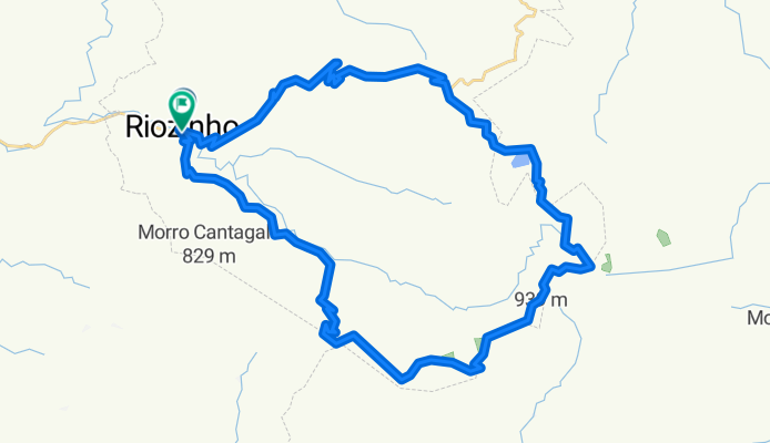
Pedal in Riozinho passing through the indigenous reserve. The first 22 km are practically all climbs, whereas the last 14 km are all descents. It's a tiring ride, especially if done on hot days, due to the initial 22 km; I do not recommend it for those who are not used to it. I suggest bringing some type of water purifier, either in tablets or another method, as the last water tap will be at a small church approximately 13 km in. There are some streams close to the road, apparently clean, mostly because they are in the higher parts of the hills, but it is good to use the purifier to ensure. There are no food points; you have to bring your own. Before entering the indigenous reserve, there is a sign that advises against the entry of unauthorized persons, as it is a federal reserve. After the reserve, you will have to pass through a private property, nothing that good manners cannot help with. The lagoon of Forja South will be the last attraction before the descent; from there, it is 14 km downhill to the town.
- -:--
- Duration
- 51.8 km
- Distance
- 1,027 m
- Ascent
- 1,026 m
- Descent
- ---
- Avg. speed
- ---
- Max. altitude

Route highlights
Points of interest along the route
Point of interest after 8.1 km
Último comércio, mas dependendo do horário estará fechado...
Point of interest after 25 km
Início da Reserva Indígena.
Point of interest after 26.6 km
Estrada para a aldeia indígena.
Continue with Bikemap
Use, edit, or download this cycling route
You would like to ride Riozinho - Reserva Indígena or customize it for your own trip? Here is what you can do with this Bikemap route:
Free features
- Save this route as favorite or in collections
- Copy & plan your own version of this route
- Sync your route with Garmin or Wahoo
Premium features
Free trial for 3 days, or one-time payment. More about Bikemap Premium.
- Navigate this route on iOS & Android
- Export a GPX / KML file of this route
- Create your custom printout (try it for free)
- Download this route for offline navigation
Discover more Premium features.
Get Bikemap PremiumFrom our community
Other popular routes starting in Rolante
 Circuito Cascatas e Montanhas Dia 1 - 2015
- Distance
- 37.3 km
- Ascent
- 1,055 m
- Descent
- 541 m
- Location
- Rolante, Rio Grande do Sul, Brazil
 primeiro 150 km
- Distance
- 155.5 km
- Ascent
- 4,219 m
- Descent
- 4,220 m
- Location
- Rolante, Rio Grande do Sul, Brazil
 Igreja Rolante- Lago S. Bernardo- Boa Esperança CLONED FROM ROUTE 574133
- Distance
- 55.1 km
- Ascent
- 1,370 m
- Descent
- 1,370 m
- Location
- Rolante, Rio Grande do Sul, Brazil
 Ilha Nova,Santa Lúcia, Maragata, Boa Esperança, Trilhas novas.
- Distance
- 53.9 km
- Ascent
- 1,080 m
- Descent
- 1,079 m
- Location
- Rolante, Rio Grande do Sul, Brazil
 Sumidouro
- Distance
- 88.4 km
- Ascent
- 1,309 m
- Descent
- 1,309 m
- Location
- Rolante, Rio Grande do Sul, Brazil
 Circuito Cascatas e Montanhas Dia 2 Original
- Distance
- 29.4 km
- Ascent
- 1,080 m
- Descent
- 704 m
- Location
- Rolante, Rio Grande do Sul, Brazil
 Riozinho - Reserva Indígena
- Distance
- 51.8 km
- Ascent
- 1,027 m
- Descent
- 1,026 m
- Location
- Rolante, Rio Grande do Sul, Brazil
 Igreja Rolante- Lago S. Bernardo- Boa Esperança
- Distance
- 55.1 km
- Ascent
- 1,370 m
- Descent
- 1,370 m
- Location
- Rolante, Rio Grande do Sul, Brazil
Open it in the app