

IST_Kompatsch - Saltria - Kompatsch
A cycling route starting in Siusi, Trentino-Alto Adige, Italy.
Overview
About this route
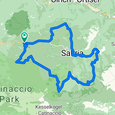
Streckenführung: Kompatsch - Weg 7 - Mahlknecht Hütte - Weg 8a u. 8 - Weg 7, Richtung Zallinger Hütte - Weg 9 - Saltria - Weg 11 - Weg 19 - Weg 9 - Sporthotel Sonne - Weg 6b - Sanon - Weg 6b - Weg 3 - Monte Piz - Kompatsch
Streckenbeschaffenheit: Asphalt sowie Wald- und Wanderwege, z. T. mit grobem Schotter oder Betonplatten, z. T. (Weg 7, Richtung Zallinger) schmal! An manchen Stellen ist Schieben nicht zu vermeiden. Bemerkungen: Aufgezeichnet mit einem Garmin eTrex Vista im September 2013 und hier überarbeitet- -:--
- Duration
- 28.4 km
- Distance
- 775 m
- Ascent
- 774 m
- Descent
- ---
- Avg. speed
- ---
- Max. altitude

Continue with Bikemap
Use, edit, or download this cycling route
You would like to ride IST_Kompatsch - Saltria - Kompatsch or customize it for your own trip? Here is what you can do with this Bikemap route:
Free features
- Save this route as favorite or in collections
- Copy & plan your own version of this route
- Sync your route with Garmin or Wahoo
Premium features
Free trial for 3 days, or one-time payment. More about Bikemap Premium.
- Navigate this route on iOS & Android
- Export a GPX / KML file of this route
- Create your custom printout (try it for free)
- Download this route for offline navigation
Discover more Premium features.
Get Bikemap PremiumFrom our community
Other popular routes starting in Siusi
 13 Seiser Alm
- Distance
- 15.3 km
- Ascent
- 492 m
- Descent
- 495 m
- Location
- Siusi, Trentino-Alto Adige, Italy
 Ausfahrt von Siusi nach Kastelruth
- Distance
- 10.8 km
- Ascent
- 846 m
- Descent
- 0 m
- Location
- Siusi, Trentino-Alto Adige, Italy
 Seis Bolzano
- Distance
- 22.8 km
- Ascent
- 275 m
- Descent
- 1,005 m
- Location
- Siusi, Trentino-Alto Adige, Italy
 Rikiroute
- Distance
- 38.1 km
- Ascent
- 2,999 m
- Descent
- 2,478 m
- Location
- Siusi, Trentino-Alto Adige, Italy
 IST_Seis - Völs - Seis
- Distance
- 20.8 km
- Ascent
- 607 m
- Descent
- 603 m
- Location
- Siusi, Trentino-Alto Adige, Italy
 alpe di siusi - rifugio zallinger
- Distance
- 25 km
- Ascent
- 764 m
- Descent
- 764 m
- Location
- Siusi, Trentino-Alto Adige, Italy
 Schildberghof - Compatsch
- Distance
- 8 km
- Ascent
- 686 m
- Descent
- 24 m
- Location
- Siusi, Trentino-Alto Adige, Italy
 giro dell'alpe di siusi
- Distance
- 27.3 km
- Ascent
- 851 m
- Descent
- 852 m
- Location
- Siusi, Trentino-Alto Adige, Italy
Open it in the app