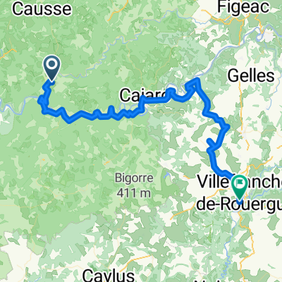
Dordogne 20130712
A cycling route starting in Cajarc, Languedoc-Roussillon-Midi-Pyrénées, France.
Overview
About this route
Z údolà řeky Cele k jeskyni Pech Merle. K nádhernému městečku Saint Cirq  Lapopie nad řekou Lot. Dál podél řeky Lot k městečku Calvignac a vzhůru do kopců do městečka limogne en Quercy. A zvlněnou krajinou do Villefranche de Rouergue. Závěr po hlavnà silnici,která byla v té době naštěstà v opravě.
- -:--
- Duration
- 66.7 km
- Distance
- 572 m
- Ascent
- 486 m
- Descent
- ---
- Avg. speed
- ---
- Max. altitude
Route quality
Waytypes & surfaces along the route
Waytypes
Road
24.1 km
(36 %)
Quiet road
18.1 km
(27 %)
Surfaces
Paved
20.9 km
(31 %)
Unpaved
3 km
(4 %)
Asphalt
20.4 km
(31 %)
Unpaved (undefined)
2.2 km
(3 %)
Continue with Bikemap
Use, edit, or download this cycling route
You would like to ride Dordogne 20130712 or customize it for your own trip? Here is what you can do with this Bikemap route:
Free features
- Save this route as favorite or in collections
- Copy & plan your own version of this route
- Sync your route with Garmin or Wahoo
Premium features
Free trial for 3 days, or one-time payment. More about Bikemap Premium.
- Navigate this route on iOS & Android
- Export a GPX / KML file of this route
- Create your custom printout (try it for free)
- Download this route for offline navigation
Discover more Premium features.
Get Bikemap PremiumFrom our community
Other popular routes starting in Cajarc
- ETAPE N°04
- Distance
- 79.4 km
- Ascent
- 824 m
- Descent
- 695 m
- Location
- Cajarc, Languedoc-Roussillon-Midi-Pyrénées, France
- Vallée du Lot et du Celé
- Distance
- 103.6 km
- Ascent
- 472 m
- Descent
- 472 m
- Location
- Cajarc, Languedoc-Roussillon-Midi-Pyrénées, France
- Camboulan_Tour_02
- Distance
- 21.7 km
- Ascent
- 324 m
- Descent
- 322 m
- Location
- Cajarc, Languedoc-Roussillon-Midi-Pyrénées, France
- Od Dordogne do Provence 4.etapa
- Distance
- 77.2 km
- Ascent
- 849 m
- Descent
- 740 m
- Location
- Cajarc, Languedoc-Roussillon-Midi-Pyrénées, France
- 2019-31 Limogne-en-Quercy to Montauban
- Distance
- 71.6 km
- Ascent
- 267 m
- Descent
- 481 m
- Location
- Cajarc, Languedoc-Roussillon-Midi-Pyrénées, France
- Limogne en Quercy - Durfort-Lacapelette - St. Martin
- Distance
- 95.3 km
- Ascent
- 1,122 m
- Descent
- 1,361 m
- Location
- Cajarc, Languedoc-Roussillon-Midi-Pyrénées, France
- St Cirq a Montsalvy
- Distance
- 104.4 km
- Ascent
- 1,316 m
- Descent
- 803 m
- Location
- Cajarc, Languedoc-Roussillon-Midi-Pyrénées, France
- St Cirq Lapopie - Caylus
- Distance
- 34.4 km
- Ascent
- 371 m
- Descent
- 380 m
- Location
- Cajarc, Languedoc-Roussillon-Midi-Pyrénées, France
Open it in the app