

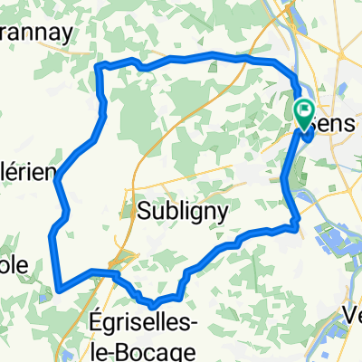
7 Tour de France - Sens _ Gien
A cycling route starting in Sens, Bourgogne-Franche-Comté, France.
Overview
About this route
Quiet side roads, more or less car-free
- -:--
- Duration
- 96.2 km
- Distance
- 339 m
- Ascent
- 288 m
- Descent
- ---
- Avg. speed
- ---
- Max. altitude

Route quality
Waytypes & surfaces along the route
Waytypes
Road
24.1 km
(25 %)
Quiet road
8.7 km
(9 %)
Surfaces
Paved
24.1 km
(25 %)
Asphalt
24.1 km
(25 %)
Undefined
72.2 km
(75 %)
Continue with Bikemap
Use, edit, or download this cycling route
You would like to ride 7 Tour de France - Sens _ Gien or customize it for your own trip? Here is what you can do with this Bikemap route:
Free features
- Save this route as favorite or in collections
- Copy & plan your own version of this route
- Split it into stages to create a multi-day tour
- Sync your route with Garmin or Wahoo
Premium features
Free trial for 3 days, or one-time payment. More about Bikemap Premium.
- Navigate this route on iOS & Android
- Export a GPX / KML file of this route
- Create your custom printout (try it for free)
- Download this route for offline navigation
Discover more Premium features.
Get Bikemap PremiumFrom our community
Other popular routes starting in Sens
 1. Sens - Montargis
- Distance
- 54.5 km
- Ascent
- 291 m
- Descent
- 282 m
- Location
- Sens, Bourgogne-Franche-Comté, France
 Paris-Lausanne prologue
- Distance
- 475 km
- Ascent
- 1,884 m
- Descent
- 1,579 m
- Location
- Sens, Bourgogne-Franche-Comté, France
 Ostia-Parigi_route
- Distance
- 1,877 km
- Ascent
- 3,546 m
- Descent
- 3,582 m
- Location
- Sens, Bourgogne-Franche-Comté, France
 7 Tour de France - Sens _ Gien
- Distance
- 96.2 km
- Ascent
- 339 m
- Descent
- 288 m
- Location
- Sens, Bourgogne-Franche-Comté, France
 Villeneuve la dondagre
- Distance
- 38.7 km
- Ascent
- 247 m
- Descent
- 245 m
- Location
- Sens, Bourgogne-Franche-Comté, France
 Sens —— Fontainebleau
- Distance
- 63.5 km
- Ascent
- 529 m
- Descent
- 522 m
- Location
- Sens, Bourgogne-Franche-Comté, France
 Sens - Parigi
- Distance
- 117.1 km
- Ascent
- 473 m
- Descent
- 499 m
- Location
- Sens, Bourgogne-Franche-Comté, France
 Retour étape 3
- Distance
- 133.5 km
- Ascent
- 617 m
- Descent
- 598 m
- Location
- Sens, Bourgogne-Franche-Comté, France
Open it in the app