

Basel out and back
A cycling route starting in Basel, Canton of Basel-City, Switzerland.
Overview
About this route
For you roadies, this is a great little out and back covering flats and some hills and will bring you back to the Basel SBB (main station) which is a couple of kms from where it begins.
- -:--
- Duration
- 64.7 km
- Distance
- 890 m
- Ascent
- 893 m
- Descent
- ---
- Avg. speed
- 609 m
- Max. altitude
Route quality
Waytypes & surfaces along the route
Waytypes
Road
12.9 km
(20 %)
Quiet road
11.6 km
(18 %)
Surfaces
Paved
44 km
(68 %)
Unpaved
4.5 km
(7 %)
Asphalt
44 km
(68 %)
Gravel
2.6 km
(4 %)
Route highlights
Points of interest along the route
Point of interest after 2.4 km
You can turn left here and take the bike path through the forest. It can be tricky with a few turns through the forest but stay in the general map direction and you will hit the Wiese estuary. Follow the Wiese until where the route crosses over the water and rejoin the mapped route.
Point of interest after 60.2 km
This area has changed due to Novartis St Johan campus development. Direction and route remain almost identical through this section now just with the inclusion of a slightly different road layout.
Continue with Bikemap
Use, edit, or download this cycling route
You would like to ride Basel out and back or customize it for your own trip? Here is what you can do with this Bikemap route:
Free features
- Save this route as favorite or in collections
- Copy & plan your own version of this route
- Sync your route with Garmin or Wahoo
Premium features
Free trial for 3 days, or one-time payment. More about Bikemap Premium.
- Navigate this route on iOS & Android
- Export a GPX / KML file of this route
- Create your custom printout (try it for free)
- Download this route for offline navigation
Discover more Premium features.
Get Bikemap PremiumFrom our community
Other popular routes starting in Basel
 Basel to Zurich
- Distance
- 94 km
- Ascent
- 922 m
- Descent
- 776 m
- Location
- Basel, Canton of Basel-City, Switzerland
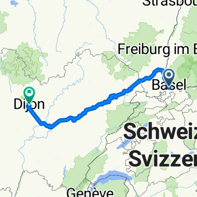 Basel Dijon
- Distance
- 303.4 km
- Ascent
- 1,736 m
- Descent
- 1,768 m
- Location
- Basel, Canton of Basel-City, Switzerland
 Jura 2025 Etappe 1
- Distance
- 79.6 km
- Ascent
- 1,879 m
- Descent
- 1,634 m
- Location
- Basel, Canton of Basel-City, Switzerland
 Moderate route in
- Distance
- 56.9 km
- Ascent
- 1,144 m
- Descent
- 1,127 m
- Location
- Basel, Canton of Basel-City, Switzerland
 Basel-Blauen-Basel
- Distance
- 52.8 km
- Ascent
- 885 m
- Descent
- 882 m
- Location
- Basel, Canton of Basel-City, Switzerland
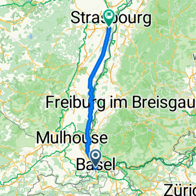 Basel - Illkirch-Graffenstaden
- Distance
- 126.4 km
- Ascent
- 58 m
- Descent
- 193 m
- Location
- Basel, Canton of Basel-City, Switzerland
 Basel-Südschwarzwaldrunde
- Distance
- 53.9 km
- Ascent
- 406 m
- Descent
- 392 m
- Location
- Basel, Canton of Basel-City, Switzerland
 Tag 1: Basel - Rothenburg LU
- Distance
- 99.6 km
- Ascent
- 1,282 m
- Descent
- 1,069 m
- Location
- Basel, Canton of Basel-City, Switzerland
Open it in the app