
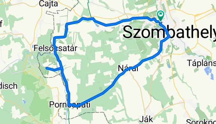
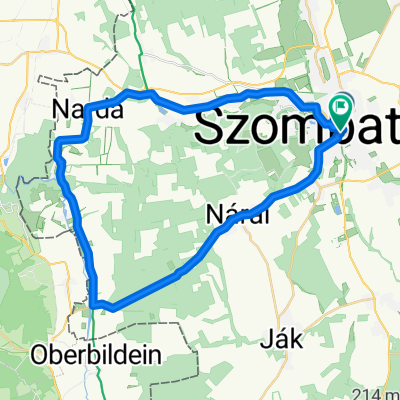
40km-es déli kör
A cycling route starting in Szombathely, Vas County, Hungary.
Overview
About this route
- -:--
- Duration
- 43.1 km
- Distance
- 194 m
- Ascent
- 192 m
- Descent
- ---
- Avg. speed
- 295 m
- Max. altitude

Route quality
Waytypes & surfaces along the route
Waytypes
Road
4.7 km
(11 %)
Quiet road
3.9 km
(9 %)
Surfaces
Paved
14.2 km
(33 %)
Asphalt
13.8 km
(32 %)
Paved (undefined)
0.4 km
(1 %)
Undefined
28.8 km
(67 %)
Route highlights
Points of interest along the route
Point of interest after 17.3 km
Pornóapáti - Gát és vízerőmű a Pinka folyón
Point of interest after 22.7 km
Judit buschenschank - borozo
Continue with Bikemap
Use, edit, or download this cycling route
You would like to ride 40km-es déli kör or customize it for your own trip? Here is what you can do with this Bikemap route:
Free features
- Save this route as favorite or in collections
- Copy & plan your own version of this route
- Sync your route with Garmin or Wahoo
Premium features
Free trial for 3 days, or one-time payment. More about Bikemap Premium.
- Navigate this route on iOS & Android
- Export a GPX / KML file of this route
- Create your custom printout (try it for free)
- Download this route for offline navigation
Discover more Premium features.
Get Bikemap PremiumFrom our community
Other popular routes starting in Szombathely
 Szombathely -Szombathely (Szhely-Gyöngyös1000/I. nap)
- Distance
- 344.1 km
- Ascent
- 452 m
- Descent
- 312 m
- Location
- Szombathely, Vas County, Hungary
 Váci Mihály utca, Szombathely - Váci Mihály utca, Szombathely
- Distance
- 33.8 km
- Ascent
- 239 m
- Descent
- 241 m
- Location
- Szombathely, Vas County, Hungary
 Út a Feistritz am Wechsel-i várkastélyhoz
- Distance
- 169.4 km
- Ascent
- 726 m
- Descent
- 726 m
- Location
- Szombathely, Vas County, Hungary
 40km-es déli kör
- Distance
- 43.1 km
- Ascent
- 194 m
- Descent
- 192 m
- Location
- Szombathely, Vas County, Hungary
 könnyed kikapcsolódás
- Distance
- 17.4 km
- Ascent
- 40 m
- Descent
- 41 m
- Location
- Szombathely, Vas County, Hungary
 Hajdú utca, Szombathely - Hajdú utca, Szombathely
- Distance
- 101.3 km
- Ascent
- 460 m
- Descent
- 458 m
- Location
- Szombathely, Vas County, Hungary
 VELOREGIO_05.
- Distance
- 40.2 km
- Ascent
- 189 m
- Descent
- 192 m
- Location
- Szombathely, Vas County, Hungary
 Szinesei majoros erdei csapatós
- Distance
- 40.5 km
- Ascent
- 135 m
- Descent
- 132 m
- Location
- Szombathely, Vas County, Hungary
Open it in the app