

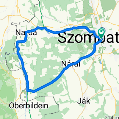
40km-es északi kör
A cycling route starting in Szombathely, Vas County, Hungary.
Overview
About this route
- -:--
- Duration
- 38.4 km
- Distance
- 197 m
- Ascent
- 193 m
- Descent
- ---
- Avg. speed
- 377 m
- Max. altitude

Route quality
Waytypes & surfaces along the route
Waytypes
Quiet road
8.4 km
(22 %)
Road
6.1 km
(16 %)
Surfaces
Paved
29.1 km
(76 %)
Unpaved
1.2 km
(3 %)
Asphalt
29.1 km
(76 %)
Gravel
1.2 km
(3 %)
Undefined
8.1 km
(21 %)
Route highlights
Points of interest along the route
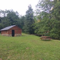
Point of interest after 17.8 km
Bozsoki Sibrik Kastélyszálló
Continue with Bikemap
Use, edit, or download this cycling route
You would like to ride 40km-es északi kör or customize it for your own trip? Here is what you can do with this Bikemap route:
Free features
- Save this route as favorite or in collections
- Copy & plan your own version of this route
- Sync your route with Garmin or Wahoo
Premium features
Free trial for 3 days, or one-time payment. More about Bikemap Premium.
- Navigate this route on iOS & Android
- Export a GPX / KML file of this route
- Create your custom printout (try it for free)
- Download this route for offline navigation
Discover more Premium features.
Get Bikemap PremiumFrom our community
Other popular routes starting in Szombathely
 Szinesei majoros erdei csapatós
- Distance
- 40.5 km
- Ascent
- 135 m
- Descent
- 132 m
- Location
- Szombathely, Vas County, Hungary
 40km-es északi kör
- Distance
- 38.4 km
- Ascent
- 197 m
- Descent
- 193 m
- Location
- Szombathely, Vas County, Hungary
 Út a Feistritz am Wechsel-i várkastélyhoz
- Distance
- 169.4 km
- Ascent
- 726 m
- Descent
- 726 m
- Location
- Szombathely, Vas County, Hungary
 Szombathely -Szombathely (Szhely-Gyöngyös1000/I. nap)
- Distance
- 344.1 km
- Ascent
- 452 m
- Descent
- 312 m
- Location
- Szombathely, Vas County, Hungary
 #Home -Hörman-Home
- Distance
- 62.5 km
- Ascent
- 3,308 m
- Descent
- 3,315 m
- Location
- Szombathely, Vas County, Hungary
 VELOREGIO_05.
- Distance
- 40.2 km
- Ascent
- 189 m
- Descent
- 192 m
- Location
- Szombathely, Vas County, Hungary
 40km-es déli kör
- Distance
- 43.1 km
- Ascent
- 194 m
- Descent
- 192 m
- Location
- Szombathely, Vas County, Hungary
 Váci Mihály utca, Szombathely - Váci Mihály utca, Szombathely
- Distance
- 33.8 km
- Ascent
- 239 m
- Descent
- 241 m
- Location
- Szombathely, Vas County, Hungary
Open it in the app