

08_RR_2014_Gränichen - Birmensdorf
A cycling route starting in Gränichen, Canton of Aargau, Switzerland.
Overview
About this route
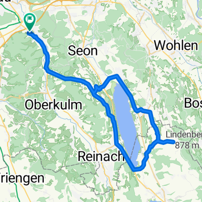
Gränichen - Birmensdorf 42.55km 870hm
- -:--
- Duration
- 42.5 km
- Distance
- 905 m
- Ascent
- 840 m
- Descent
- ---
- Avg. speed
- ---
- Max. altitude

Route quality
Waytypes & surfaces along the route
Waytypes
Quiet road
17 km
(40 %)
Road
10.6 km
(25 %)
Surfaces
Paved
26.8 km
(63 %)
Unpaved
4.7 km
(11 %)
Asphalt
20.8 km
(49 %)
Paved (undefined)
6 km
(14 %)
Route highlights
Points of interest along the route
Point of interest after 0 km
00km Start 8. Etappe Gränichen Oberdorf, Bahnhof Zug S14
Point of interest after 5.5 km
5.20km Seon, Bahnhof Zug S9
Point of interest after 11 km
10.60km Egliswil, Lenzburgerstrasse (vor dem Wald) nur Verpflegung
Point of interest after 15.5 km
15.20km Dottikon-Dintikon, Bahnhof Zug S26
Point of interest after 18.8 km
18.30km Hägglingen, Huematten Bus 345 und 346
Point of interest after 23.6 km
23.40km Niederwil AG, Post Bus 332 und 336
Point of interest after 29.5 km
29.30 Bellikon, Post Bus 320 / 321 / 331 / 445
Point of interest after 35.3 km
35.10km Rudolfstetten, Bahnhof Zug S17
Point of interest after 39.3 km
38.90km Stierliberg, Birmensdorf nur Verpflegung
Point of interest after 42.5 km
42.26km Ziel 8. Etappe Birmensdorf, Bahnhof Zug S9 und S15 Bus 215 / 227 / 245 / 314
Continue with Bikemap
Use, edit, or download this cycling route
You would like to ride 08_RR_2014_Gränichen - Birmensdorf or customize it for your own trip? Here is what you can do with this Bikemap route:
Free features
- Save this route as favorite or in collections
- Copy & plan your own version of this route
- Sync your route with Garmin or Wahoo
Premium features
Free trial for 3 days, or one-time payment. More about Bikemap Premium.
- Navigate this route on iOS & Android
- Export a GPX / KML file of this route
- Create your custom printout (try it for free)
- Download this route for offline navigation
Discover more Premium features.
Get Bikemap PremiumFrom our community
Other popular routes starting in Gränichen
 Gränichen-Leutwil-Mosen-Schongau-Boniswil-Leutwil-Gränichen
- Distance
- 48.5 km
- Ascent
- 682 m
- Descent
- 680 m
- Location
- Gränichen, Canton of Aargau, Switzerland
 Gänstelstrasse 29, Gränichen nach Schiffländi 4, Stein am Rhein
- Distance
- 97.4 km
- Ascent
- 1,498 m
- Descent
- 1,516 m
- Location
- Gränichen, Canton of Aargau, Switzerland
 Grä-Schöftland-Rehag-Reinach-Gränichen
- Distance
- 44.3 km
- Ascent
- 493 m
- Descent
- 493 m
- Location
- Gränichen, Canton of Aargau, Switzerland
 Anstieg Rütihof
- Distance
- 2.4 km
- Ascent
- 181 m
- Descent
- 14 m
- Location
- Gränichen, Canton of Aargau, Switzerland
 08_RR_2014_Gränichen - Birmensdorf
- Distance
- 42.5 km
- Ascent
- 905 m
- Descent
- 840 m
- Location
- Gränichen, Canton of Aargau, Switzerland
 Talbachstrasse 23, Gränichen to Talbachstrasse 23, Gränichen
- Distance
- 97.3 km
- Ascent
- 2,493 m
- Descent
- 2,506 m
- Location
- Gränichen, Canton of Aargau, Switzerland
 Gränichen- Hunzenschwil-Seon-Liebegg-Gränichen
- Distance
- 20.8 km
- Ascent
- 317 m
- Descent
- 303 m
- Location
- Gränichen, Canton of Aargau, Switzerland
 RR_2014_Gränichen_8
- Distance
- 42.2 km
- Ascent
- 904 m
- Descent
- 843 m
- Location
- Gränichen, Canton of Aargau, Switzerland
Open it in the app