
Durch das württembergische Allgäü
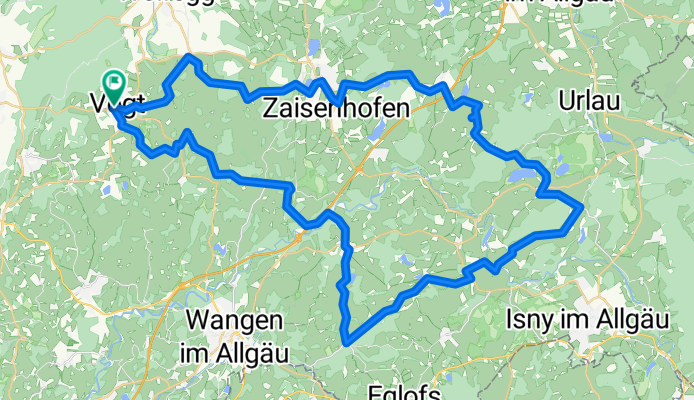
A cycling route starting in Vogt, Baden-Wurttemberg, Germany.
Overview
About this route
Über Rötenbach, Kisslegg und Gebrazhofen gelangen wir zum Badsee nach Beuren. Durch das liebliche und ruhige Sommersbachtal geht es zurück über Giessen, Ratzenried und Leupolz nach Vogt.
- -:--
- Duration
- 66.1 km
- Distance
- 420 m
- Ascent
- 421 m
- Descent
- ---
- Avg. speed
- ---
- Max. altitude

Route quality
Waytypes & surfaces along the route
Waytypes
Quiet road
39.8 km
(60 %)
Road
23 km
(35 %)
Surfaces
Paved
35.7 km
(54 %)
Asphalt
35.7 km
(54 %)
Paved (undefined)
0.1 km
(<1 %)
Undefined
30.4 km
(46 %)
Continue with Bikemap
Use, edit, or download this cycling route
You would like to ride Durch das württembergische Allgäü or customize it for your own trip? Here is what you can do with this Bikemap route:
Free features
- Save this route as favorite or in collections
- Copy & plan your own version of this route
- Sync your route with Garmin or Wahoo
Premium features
Free trial for 3 days, or one-time payment. More about Bikemap Premium.
- Navigate this route on iOS & Android
- Export a GPX / KML file of this route
- Create your custom printout (try it for free)
- Download this route for offline navigation
Discover more Premium features.
Get Bikemap PremiumFrom our community
Other popular routes starting in Vogt
 24.08.2020 33 Seen-Weiher-Tour
- Distance
- 98 km
- Ascent
- 1,367 m
- Descent
- 1,367 m
- Location
- Vogt, Baden-Wurttemberg, Germany
 Vogter Runde
- Distance
- 47.2 km
- Ascent
- 1,470 m
- Descent
- 1,468 m
- Location
- Vogt, Baden-Wurttemberg, Germany
 Vogt - Legau - Vogt
- Distance
- 88 km
- Ascent
- 440 m
- Descent
- 439 m
- Location
- Vogt, Baden-Wurttemberg, Germany
 Gute Radler - Tour Vogt
- Distance
- 122.1 km
- Ascent
- 348 m
- Descent
- 599 m
- Location
- Vogt, Baden-Wurttemberg, Germany
 Durch das württembergische Allgäü
- Distance
- 66.1 km
- Ascent
- 420 m
- Descent
- 421 m
- Location
- Vogt, Baden-Wurttemberg, Germany
 1. OB Ritt Tag 1 und 3
- Distance
- 47.3 km
- Ascent
- 517 m
- Descent
- 529 m
- Location
- Vogt, Baden-Wurttemberg, Germany
 Grüner Baum-St, Gallen
- Distance
- 79.5 km
- Ascent
- 830 m
- Descent
- 771 m
- Location
- Vogt, Baden-Wurttemberg, Germany
 Rund um Vogt
- Distance
- 551.1 km
- Ascent
- 2,038 m
- Descent
- 2,017 m
- Location
- Vogt, Baden-Wurttemberg, Germany
Open it in the app