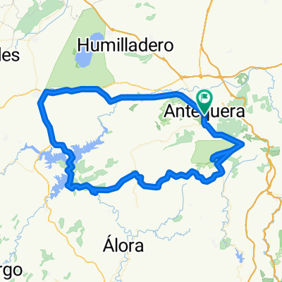
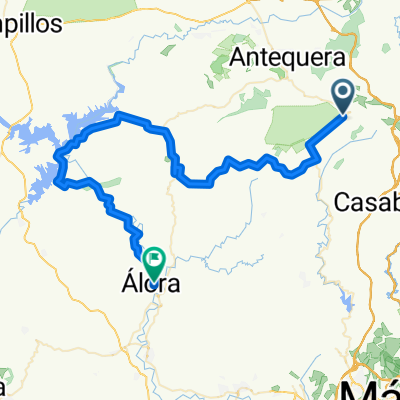
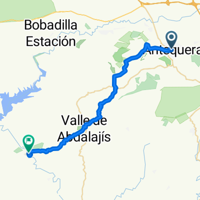
Vuelta El Chorro desde Antequera
A cycling route starting in Antequera, Andalusia, Spain.
Overview
About this route
Antaquera, Campillos, Ardales, El Chorro, Valle de Abdalajis, Villanueva de la Concepción, Antequera
- -:--
- Duration
- 111.8 km
- Distance
- 1,269 m
- Ascent
- 1,257 m
- Descent
- ---
- Avg. speed
- ---
- Max. altitude
Route quality
Waytypes & surfaces along the route
Waytypes
Road
39.1 km
(35 %)
Quiet road
4.5 km
(4 %)
Surfaces
Paved
71.6 km
(64 %)
Asphalt
71.6 km
(64 %)
Undefined
40.3 km
(36 %)
Continue with Bikemap
Use, edit, or download this cycling route
You would like to ride Vuelta El Chorro desde Antequera or customize it for your own trip? Here is what you can do with this Bikemap route:
Free features
- Save this route as favorite or in collections
- Copy & plan your own version of this route
- Split it into stages to create a multi-day tour
- Sync your route with Garmin or Wahoo
Premium features
Free trial for 3 days, or one-time payment. More about Bikemap Premium.
- Navigate this route on iOS & Android
- Export a GPX / KML file of this route
- Create your custom printout (try it for free)
- Download this route for offline navigation
Discover more Premium features.
Get Bikemap PremiumFrom our community
Other popular routes starting in Antequera
- Start md berg och sen uuuuutttföööörrr...
- Distance
- 122.2 km
- Ascent
- 1,397 m
- Descent
- 1,381 m
- Location
- Antequera, Andalusia, Spain
- Antequera - Subida al Torcal - Antequera - Mollina - Humilladero - Fuente de Piedra - Sierra de Yeguas
- Distance
- 76.2 km
- Ascent
- 1,080 m
- Descent
- 1,118 m
- Location
- Antequera, Andalusia, Spain
- 9ª R.N.9 km Eta Antequera - Valdepeñas de Jaén 163,7km
- Distance
- 172.4 km
- Ascent
- 1,893 m
- Descent
- 1,424 m
- Location
- Antequera, Andalusia, Spain
- Antequera-Lucena CRI
- Distance
- 53.7 km
- Ascent
- 473 m
- Descent
- 461 m
- Location
- Antequera, Andalusia, Spain
- Antequera-Málaga
- Distance
- 56.3 km
- Ascent
- 669 m
- Descent
- 1,175 m
- Location
- Antequera, Andalusia, Spain
- 9 ETAPA CARRETERA CCCS2018 (BUS)
- Distance
- 78.3 km
- Ascent
- 925 m
- Descent
- 963 m
- Location
- Antequera, Andalusia, Spain
- Vuelta El Chorro desde Antequera
- Distance
- 111.8 km
- Ascent
- 1,269 m
- Descent
- 1,257 m
- Location
- Antequera, Andalusia, Spain
- DESAFIO TORCAL
- Distance
- 42.6 km
- Ascent
- 1,091 m
- Descent
- 1,088 m
- Location
- Antequera, Andalusia, Spain
Open it in the app