

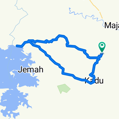
CIEURIH - MALONGPONG
A cycling route starting in Majalengka, West Java, Indonesia.
Overview
About this route
ASPAL MULUS DAN SEDIKIT JALAN ASPAL LEPAS , TANJAKAN DAN TURUNAN SEIMBANG
- -:--
- Duration
- 28.7 km
- Distance
- 498 m
- Ascent
- 467 m
- Descent
- ---
- Avg. speed
- ---
- Max. altitude

Route quality
Waytypes & surfaces along the route
Waytypes
Quiet road
17.8 km
(62 %)
Road
1.7 km
(6 %)
Surfaces
Paved
3.7 km
(13 %)
Asphalt
3.7 km
(13 %)
Undefined
25 km
(87 %)
Continue with Bikemap
Use, edit, or download this cycling route
You would like to ride CIEURIH - MALONGPONG or customize it for your own trip? Here is what you can do with this Bikemap route:
Free features
- Save this route as favorite or in collections
- Copy & plan your own version of this route
- Sync your route with Garmin or Wahoo
Premium features
Free trial for 3 days, or one-time payment. More about Bikemap Premium.
- Navigate this route on iOS & Android
- Export a GPX / KML file of this route
- Create your custom printout (try it for free)
- Download this route for offline navigation
Discover more Premium features.
Get Bikemap PremiumFrom our community
Other popular routes starting in Majalengka
 sawiyah day 2 tegal gede
- Distance
- 35.3 km
- Ascent
- 946 m
- Descent
- 946 m
- Location
- Majalengka, West Java, Indonesia
 Relaxed route
- Distance
- 9.7 km
- Ascent
- 73 m
- Descent
- 75 m
- Location
- Majalengka, West Java, Indonesia
 Jalan Satari 4, Kecamatan Majalengka to Jalan Raya K H Abdul Halim 156, Kecamatan Majalengka
- Distance
- 3.6 km
- Ascent
- 51 m
- Descent
- 63 m
- Location
- Majalengka, West Java, Indonesia
 Route to Jalan Majalengka-Kadipaten 1, Kecamatan Kadipaten
- Distance
- 18.7 km
- Ascent
- 80 m
- Descent
- 85 m
- Location
- Majalengka, West Java, Indonesia
 PANCURENDANG
- Distance
- 14 km
- Ascent
- 627 m
- Descent
- 396 m
- Location
- Majalengka, West Java, Indonesia
 CIEURIH - MALONGPONG
- Distance
- 28.7 km
- Ascent
- 498 m
- Descent
- 467 m
- Location
- Majalengka, West Java, Indonesia
 CIKEUSIK - PASIRAYU
- Distance
- 31.2 km
- Ascent
- 533 m
- Descent
- 492 m
- Location
- Majalengka, West Java, Indonesia
 Jalan Lamejajar No.8, Kecamatan Cigasong to 57F3+9VC, Kecamatan Cigasong
- Distance
- 10.8 km
- Ascent
- 80 m
- Descent
- 75 m
- Location
- Majalengka, West Java, Indonesia
Open it in the app