

MTB Runde 36km - Statzing - Pürach - Götzelsdorf - Holzwinden - Lachstatt - Pfenningberg - Aigen - Haid - Schmiedgassen - Oberthal - Niederthal - Edtsdorf - Sch
A cycling route starting in Steyregg, Upper Austria, Austria.
Overview
About this route
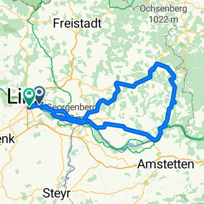
The route goes over gravel paths, goods paths, and forest paths to Götzelsdorf and along the Donausteig to Holzwinden. Passing a horse stable, the climb begins upwards to Lachstatt. The steep ascent is rewarded with a great panoramic view of the Mühlviertel. Further along forest paths leads to the summit of Pfenningberg. The route continues through the forest and on goods paths until Oberreichenbach. On a forest or meadow path, it continues to Aigen, followed by a short section on a goods path, then another forest path to Haid. On the goods path, the route continues to Schmiedgassen, where it turns right into the forest and returns via gravel paths back to Amberg. Between the fields, the route goes to Oberthal and Niederthal. In Edtsdorf, one can take a break at Mostkost Punzenberger. The route continues on the road through Gusenthal to St. Georgen an der Gusen. Along the mining area, the route returns to Statzing. WARNING: In the area of Pfenningberg, the route repeatedly goes through a no-cycling zone. Route information (1 = easy, 10 = hard) Endurance: 6 Technique: 5 Variety: 5-6
- -:--
- Duration
- 35.9 km
- Distance
- 674 m
- Ascent
- 674 m
- Descent
- ---
- Avg. speed
- ---
- Max. altitude
Route quality
Waytypes & surfaces along the route
Waytypes
Track
16.5 km
(46 %)
Quiet road
14.4 km
(40 %)
Surfaces
Paved
10.4 km
(29 %)
Unpaved
14 km
(39 %)
Asphalt
8.3 km
(23 %)
Ground
6.5 km
(18 %)
Continue with Bikemap
Use, edit, or download this cycling route
You would like to ride MTB Runde 36km - Statzing - Pürach - Götzelsdorf - Holzwinden - Lachstatt - Pfenningberg - Aigen - Haid - Schmiedgassen - Oberthal - Niederthal - Edtsdorf - Sch or customize it for your own trip? Here is what you can do with this Bikemap route:
Free features
- Save this route as favorite or in collections
- Copy & plan your own version of this route
- Sync your route with Garmin or Wahoo
Premium features
Free trial for 3 days, or one-time payment. More about Bikemap Premium.
- Navigate this route on iOS & Android
- Export a GPX / KML file of this route
- Create your custom printout (try it for free)
- Download this route for offline navigation
Discover more Premium features.
Get Bikemap PremiumFrom our community
Other popular routes starting in Steyregg
 Linz-Gramastetten-Kirchaschlag-Goli-Linz
- Distance
- 70.8 km
- Ascent
- 1,424 m
- Descent
- 1,424 m
- Location
- Steyregg, Upper Austria, Austria
 MTB Runde 55km - Satzing - Pürach - Götzelsdorf - Holzwinden - Lachstadt - Pfenningberg - Plesching - Linz-Urfahr - Lichtenberg - GIS Warte - Lichtenberg - Linz
- Distance
- 55.7 km
- Ascent
- 1,295 m
- Descent
- 1,297 m
- Location
- Steyregg, Upper Austria, Austria
 MTB Runde 45km - Statzing
- Distance
- 45.3 km
- Ascent
- 952 m
- Descent
- 952 m
- Location
- Steyregg, Upper Austria, Austria
 MTB Runde 30km
- Distance
- 30.5 km
- Ascent
- 521 m
- Descent
- 521 m
- Location
- Steyregg, Upper Austria, Austria
 20190111 Spaziergang mit Krone
- Distance
- 10.3 km
- Ascent
- 282 m
- Descent
- 281 m
- Location
- Steyregg, Upper Austria, Austria
 Nette Abendrunde
- Distance
- 39.2 km
- Ascent
- 472 m
- Descent
- 465 m
- Location
- Steyregg, Upper Austria, Austria
 Linz-Königswiesen-Grein-Linz
- Distance
- 151.6 km
- Ascent
- 935 m
- Descent
- 923 m
- Location
- Steyregg, Upper Austria, Austria
 Südlicher Pfenningberg
- Distance
- 8.9 km
- Ascent
- 416 m
- Descent
- 300 m
- Location
- Steyregg, Upper Austria, Austria
Open it in the app