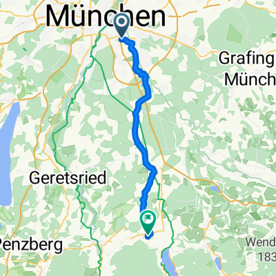
rundtour Putzbrunn
A cycling route starting in Unterhaching, Bavaria, Germany.
Overview
About this route
Sunday afternoon ride
- -:--
- Duration
- 25.3 km
- Distance
- 33 m
- Ascent
- 31 m
- Descent
- ---
- Avg. speed
- ---
- Max. altitude
Route quality
Waytypes & surfaces along the route
Waytypes
- Quiet road - 8.1 km - (32 %) 
- Path - 7.8 km - (31 %) 
Surfaces
Paved
24.3 km
(96 %)
Unpaved
0.5 km
(2 %)
- Asphalt - 24 km - (95 %) 
- Concrete - 0.3 km - (1 %) 
Continue with Bikemap
Use, edit, or download this cycling route
You would like to ride rundtour Putzbrunn or customize it for your own trip? Here is what you can do with this Bikemap route:
Free features
- Save this route as favorite or in collections
- Copy & plan your own version of this route
- Sync your route with Garmin or Wahoo
Premium features
Free trial for 3 days, or one-time payment. More about Bikemap Premium.
- Navigate this route on iOS & Android
- Export a GPX / KML file of this route
- Create your custom printout (try it for free)
- Download this route for offline navigation
Discover more Premium features.
Get Bikemap PremiumFrom our community
Other popular routes starting in Unterhaching
 rundtour Putzbrunn rundtour Putzbrunn- Distance
- 25.3 km
- Ascent
- 33 m
- Descent
- 31 m
- Location
- Unterhaching, Bavaria, Germany
 
 ala Sabrina München- Bad Tölz- München ala Sabrina München- Bad Tölz- München- Distance
- 105.1 km
- Ascent
- 499 m
- Descent
- 499 m
- Location
- Unterhaching, Bavaria, Germany
 
 Münchner Forste-Gleißental-Trailtour Münchner Forste-Gleißental-Trailtour- Distance
- 35.5 km
- Ascent
- 87 m
- Descent
- 88 m
- Location
- Unterhaching, Bavaria, Germany
 
 München Ost: Rundweg Mü-Fasangarten-Bayerbrunn-Schäftlarn-Fasangarten München Ost: Rundweg Mü-Fasangarten-Bayerbrunn-Schäftlarn-Fasangarten- Distance
- 43.1 km
- Ascent
- 222 m
- Descent
- 221 m
- Location
- Unterhaching, Bavaria, Germany
 
 Wendelstein Runde Wendelstein Runde- Distance
- 176.6 km
- Ascent
- 1,432 m
- Descent
- 1,377 m
- Location
- Unterhaching, Bavaria, Germany
 
 Südöstliche Münchner Forste-Tour Südöstliche Münchner Forste-Tour- Distance
- 68.3 km
- Ascent
- 173 m
- Descent
- 173 m
- Location
- Unterhaching, Bavaria, Germany
 
 Feierabendrunde: Ludwigshöhe Feierabendrunde: Ludwigshöhe- Distance
- 36.6 km
- Ascent
- 188 m
- Descent
- 200 m
- Location
- Unterhaching, Bavaria, Germany
 
 Perlacher Forst - Ascholding Perlacher Forst - Ascholding- Distance
- 67.7 km
- Ascent
- 485 m
- Descent
- 463 m
- Location
- Unterhaching, Bavaria, Germany
 
Open it in the app

