

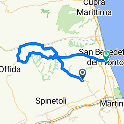
Ragnola salita per Monteprandone - Aquaviva. Discesa verso fosso di Ragnola
A cycling route starting in Monteprandone, The Marches, Italy.
Overview
About this route
Typical midweek training. You climb up to Monteprendone and then continue climbing towards Aquaviva via contrada Santa Caterina (Piceni trails) and descend on a gravel road towards the Ragnola stream.
- -:--
- Duration
- 22 km
- Distance
- 475 m
- Ascent
- 474 m
- Descent
- ---
- Avg. speed
- ---
- Max. altitude

Route quality
Waytypes & surfaces along the route
Waytypes
Quiet road
4.6 km
(21 %)
Road
2.6 km
(12 %)
Surfaces
Paved
13.6 km
(62 %)
Unpaved
2.4 km
(11 %)
Asphalt
13.6 km
(62 %)
Gravel
1.3 km
(6 %)
Continue with Bikemap
Use, edit, or download this cycling route
You would like to ride Ragnola salita per Monteprandone - Aquaviva. Discesa verso fosso di Ragnola or customize it for your own trip? Here is what you can do with this Bikemap route:
Free features
- Save this route as favorite or in collections
- Copy & plan your own version of this route
- Sync your route with Garmin or Wahoo
Premium features
Free trial for 3 days, or one-time payment. More about Bikemap Premium.
- Navigate this route on iOS & Android
- Export a GPX / KML file of this route
- Create your custom printout (try it for free)
- Download this route for offline navigation
Discover more Premium features.
Get Bikemap PremiumFrom our community
Other popular routes starting in Monteprandone
 De Via Borgo da Mare 24–34, Monteprandone à Via Ugo Foscolo 11, Centobuchi
- Distance
- 46.9 km
- Ascent
- 337 m
- Descent
- 545 m
- Location
- Monteprandone, The Marches, Italy
 Monteprandone Monteprandone
- Distance
- 23.4 km
- Ascent
- 696 m
- Descent
- 700 m
- Location
- Monteprandone, The Marches, Italy
 Cicloturistica Monteprandone
- Distance
- 26.8 km
- Ascent
- 696 m
- Descent
- 696 m
- Location
- Monteprandone, The Marches, Italy
 Ragnola salita per Monteprandone - Aquaviva. Discesa verso fosso di Ragnola
- Distance
- 22 km
- Ascent
- 475 m
- Descent
- 474 m
- Location
- Monteprandone, The Marches, Italy
 cervara ascensione
- Distance
- 141.1 km
- Ascent
- 1,636 m
- Descent
- 1,640 m
- Location
- Monteprandone, The Marches, Italy
 De Piazza dell'Aquila 2, Monteprandone à Viale Alcide De Gasperi 85, San Benedetto del Tronto
- Distance
- 35.2 km
- Ascent
- 432 m
- Descent
- 683 m
- Location
- Monteprandone, The Marches, Italy
 De Contrada Spiagge 23, Monteprandone à Viale Alcide De Gasperi 12, Centobuchi
- Distance
- 46.8 km
- Ascent
- 727 m
- Descent
- 853 m
- Location
- Monteprandone, The Marches, Italy
 De Contrada Spiagge 20, Monteprandone à Viale Alcide De Gasperi 19/A, Centobuchi
- Distance
- 47.9 km
- Ascent
- 741 m
- Descent
- 860 m
- Location
- Monteprandone, The Marches, Italy
Open it in the app