

test
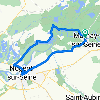
A cycling route starting in Nogent-sur-Seine, Grand Est, France.
Overview
About this route
test
- -:--
- Duration
- 179.9 km
- Distance
- 297 m
- Ascent
- 204 m
- Descent
- ---
- Avg. speed
- ---
- Max. altitude
Route quality
Waytypes & surfaces along the route
Waytypes
Cycleway
48.6 km
(27 %)
Path
43.2 km
(24 %)
Surfaces
Paved
98.9 km
(55 %)
Unpaved
19.8 km
(11 %)
Asphalt
98.9 km
(55 %)
Gravel
10.8 km
(6 %)
Continue with Bikemap
Use, edit, or download this cycling route
You would like to ride test or customize it for your own trip? Here is what you can do with this Bikemap route:
Free features
- Save this route as favorite or in collections
- Copy & plan your own version of this route
- Split it into stages to create a multi-day tour
- Sync your route with Garmin or Wahoo
Premium features
Free trial for 3 days, or one-time payment. More about Bikemap Premium.
- Navigate this route on iOS & Android
- Export a GPX / KML file of this route
- Create your custom printout (try it for free)
- Download this route for offline navigation
Discover more Premium features.
Get Bikemap PremiumFrom our community
Other popular routes starting in Nogent-sur-Seine
 sur seine
- Distance
- 49.8 km
- Ascent
- 201 m
- Descent
- 201 m
- Location
- Nogent-sur-Seine, Grand Est, France
 Von Nogent-sur-Seine bis Moret-Loing-et-Orvanne
- Distance
- 69.9 km
- Ascent
- 118 m
- Descent
- 129 m
- Location
- Nogent-sur-Seine, Grand Est, France
 Marnay - Lacs
- Distance
- 81.7 km
- Ascent
- 81 m
- Descent
- 11 m
- Location
- Nogent-sur-Seine, Grand Est, France
 Tour de France 2016 dzień 22
- Distance
- 140.4 km
- Ascent
- 319 m
- Descent
- 354 m
- Location
- Nogent-sur-Seine, Grand Est, France
 062 Nugent sur seine - saint dizier
- Distance
- 129.7 km
- Ascent
- 234 m
- Descent
- 166 m
- Location
- Nogent-sur-Seine, Grand Est, France
 Barbuise-Villeneuve-Le Mériot
- Distance
- 44.7 km
- Ascent
- 258 m
- Descent
- 256 m
- Location
- Nogent-sur-Seine, Grand Est, France
 Marnay-sur-Seine Nogent-sur-Seine and back
- Distance
- 14.4 km
- Ascent
- 38 m
- Descent
- 38 m
- Location
- Nogent-sur-Seine, Grand Est, France
 Marnay-sur-Seine 40kms round trip
- Distance
- 40.5 km
- Ascent
- 195 m
- Descent
- 196 m
- Location
- Nogent-sur-Seine, Grand Est, France
Open it in the app