

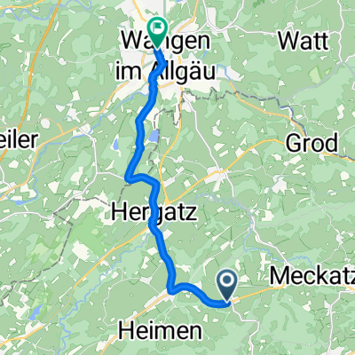
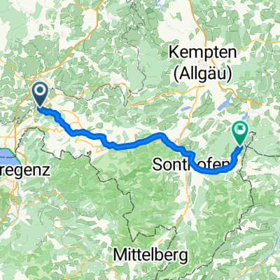
Bodensee - Königsee - Etappe 2 - Hergatz - Nesselwang
A cycling route starting in Opfenbach, Bavaria, Germany.
Overview
About this route
The Allgäu has a lot to offer! I had also trained very little: watching two stages of the Tour de France and the opening ceremony of the Olympic Games on TV doesn't really give strength for the climbs.
- -:--
- Duration
- 87.6 km
- Distance
- 791 m
- Ascent
- 466 m
- Descent
- ---
- Avg. speed
- ---
- Max. altitude
Route quality
Waytypes & surfaces along the route
Waytypes
Quiet road
52.5 km
(60 %)
Road
10.5 km
(12 %)
Surfaces
Paved
85 km
(97 %)
Unpaved
1.8 km
(2 %)
Asphalt
83.2 km
(95 %)
Paved (undefined)
1.8 km
(2 %)
Continue with Bikemap
Use, edit, or download this cycling route
You would like to ride Bodensee - Königsee - Etappe 2 - Hergatz - Nesselwang or customize it for your own trip? Here is what you can do with this Bikemap route:
Free features
- Save this route as favorite or in collections
- Copy & plan your own version of this route
- Split it into stages to create a multi-day tour
- Sync your route with Garmin or Wahoo
Premium features
Free trial for 3 days, or one-time payment. More about Bikemap Premium.
- Navigate this route on iOS & Android
- Export a GPX / KML file of this route
- Create your custom printout (try it for free)
- Download this route for offline navigation
Discover more Premium features.
Get Bikemap PremiumFrom our community
Other popular routes starting in Opfenbach
 Von Mywiler nach Scheidegg, Pfänder,Hörbranz, Hergensweiler, Wohmbrechts, Mywiler
- Distance
- 58.8 km
- Ascent
- 686 m
- Descent
- 683 m
- Location
- Opfenbach, Bavaria, Germany
 Mellatz, Opfenbach nach Bahnhofstraße, Wangen im Allgäu
- Distance
- 10.1 km
- Ascent
- 68 m
- Descent
- 147 m
- Location
- Opfenbach, Bavaria, Germany
 Scheidegg-2 Hopfen
- Distance
- 26.7 km
- Ascent
- 735 m
- Descent
- 511 m
- Location
- Opfenbach, Bavaria, Germany
 Nadenberg
- Distance
- 36.3 km
- Ascent
- 540 m
- Descent
- 525 m
- Location
- Opfenbach, Bavaria, Germany
 Bodensee - Königsee - Etappe 2 - Hergatz - Nesselwang
- Distance
- 87.6 km
- Ascent
- 791 m
- Descent
- 466 m
- Location
- Opfenbach, Bavaria, Germany
 bokö-t1
- Distance
- 154.7 km
- Ascent
- 979 m
- Descent
- 976 m
- Location
- Opfenbach, Bavaria, Germany
 Rueckfahrt vom BodenseeVM-Treffen Winter 2012
- Distance
- 169.2 km
- Ascent
- 444 m
- Descent
- 466 m
- Location
- Opfenbach, Bavaria, Germany
 Opfenbach - Jungholz
- Distance
- 66.8 km
- Ascent
- 1,121 m
- Descent
- 675 m
- Location
- Opfenbach, Bavaria, Germany
Open it in the app