
Tok a Houpák pro děti
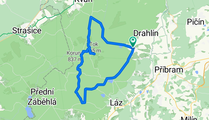
A cycling route starting in Obecnice, Central Bohemia, Czechia.
Overview
About this route
Obecnice, Malý Tok, Tok, Houpák, letiště, Obecnice
- -:--
- Duration
- 34.3 km
- Distance
- 637 m
- Ascent
- 639 m
- Descent
- ---
- Avg. speed
- ---
- Max. altitude

Route quality
Waytypes & surfaces along the route
Waytypes
Quiet road
26.5 km
(77 %)
Track
5.5 km
(16 %)
Surfaces
Paved
19.5 km
(57 %)
Unpaved
4.8 km
(14 %)
Asphalt
18.8 km
(55 %)
Gravel
3.9 km
(11 %)
Continue with Bikemap
Use, edit, or download this cycling route
You would like to ride Tok a Houpák pro děti or customize it for your own trip? Here is what you can do with this Bikemap route:
Free features
- Save this route as favorite or in collections
- Copy & plan your own version of this route
- Sync your route with Garmin or Wahoo
Premium features
Free trial for 3 days, or one-time payment. More about Bikemap Premium.
- Navigate this route on iOS & Android
- Export a GPX / KML file of this route
- Create your custom printout (try it for free)
- Download this route for offline navigation
Discover more Premium features.
Get Bikemap PremiumFrom our community
Other popular routes starting in Obecnice
 Pilská - Kozičín - Lazec - Podlesí
- Distance
- 14.4 km
- Ascent
- 248 m
- Descent
- 249 m
- Location
- Obecnice, Central Bohemia, Czechia
 Tok a Houpák pro děti
- Distance
- 34.3 km
- Ascent
- 637 m
- Descent
- 639 m
- Location
- Obecnice, Central Bohemia, Czechia
 Brdy, Vojenský újezd
- Distance
- 47.7 km
- Ascent
- 740 m
- Descent
- 754 m
- Location
- Obecnice, Central Bohemia, Czechia
 Cyklotrasy 066 - Brdy 3 v zimě
- Distance
- 46.5 km
- Ascent
- 924 m
- Descent
- 923 m
- Location
- Obecnice, Central Bohemia, Czechia
 Bratkovice - Řevnice
- Distance
- 51.3 km
- Ascent
- 486 m
- Descent
- 714 m
- Location
- Obecnice, Central Bohemia, Czechia
 Recording from 14 Aug 2017, 15:20
- Distance
- 6.5 km
- Ascent
- 257 m
- Descent
- 18 m
- Location
- Obecnice, Central Bohemia, Czechia
 Bezky jordan
- Distance
- 22.7 km
- Ascent
- 347 m
- Descent
- 347 m
- Location
- Obecnice, Central Bohemia, Czechia
 Příbram do Příbram
- Distance
- 22.6 km
- Ascent
- 507 m
- Descent
- 554 m
- Location
- Obecnice, Central Bohemia, Czechia
Open it in the app