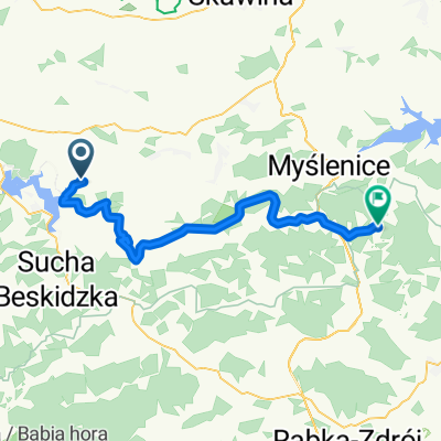
Strsz贸w-Sucha Beskidzka
A cycling route starting in Strysz贸w, Lesser Poland Voivodeship, Poland.
Overview
About this route
PKP Strysz贸w - PKP Sucha Beskidzka
- -:--
- Duration
- 27.1 km
- Distance
- 636 m
- Ascent
- 633 m
- Descent
- ---
- Avg. speed
- ---
- Avg. speed
Route quality
Waytypes & surfaces along the route
Waytypes
Quiet road
13.4 km
(49 %)
Track
6.4 km
(23 %)
Surfaces
Paved
19 km
(70 %)
Unpaved
5 km
(18 %)
Asphalt
17.7 km
(65 %)
Gravel
2.5 km
(9 %)
Continue with Bikemap
Use, edit, or download this cycling route
You would like to ride Strsz贸w-Sucha Beskidzka or customize it for your own trip? Here is what you can do with this Bikemap route:
Free features
- Save this route as favorite or in collections
- Copy & plan your own version of this route
- Sync your route with Garmin or Wahoo
Premium features
Free trial for 3 days, or one-time payment. More about Bikemap Premium.
- Navigate this route on iOS & Android
- Export a GPX / KML file of this route
- Create your custom printout (try it for free)
- Download this route for offline navigation
Discover more Premium features.
Get Bikemap PremiumFrom our community
Other popular routes starting in Strysz贸w
- Makowski - rekonesans
- Distance
- 36.1 km
- Ascent
- 729 m
- Descent
- 722 m
- Location
- Strysz贸w, Lesser Poland Voivodeship, Poland
- Mucharz do Zawoji
- Distance
- 92.6 km
- Ascent
- 1,126 m
- Descent
- 1,168 m
- Location
- Strysz贸w, Lesser Poland Voivodeship, Poland
- [GPX] Asiek - g贸rki - Proko
- Distance
- 59.5 km
- Ascent
- 799 m
- Descent
- 1,002 m
- Location
- Strysz贸w, Lesser Poland Voivodeship, Poland
- 17 mountain
- Distance
- 17.3 km
- Ascent
- 489 m
- Descent
- 490 m
- Location
- Strysz贸w, Lesser Poland Voivodeship, Poland
- Mucharz ma艂y
- Distance
- 32.6 km
- Ascent
- 548 m
- Descent
- 566 m
- Location
- Strysz贸w, Lesser Poland Voivodeship, Poland
- Dooko艂a Mucharskiego
- Distance
- 43.3 km
- Ascent
- 827 m
- Descent
- 825 m
- Location
- Strysz贸w, Lesser Poland Voivodeship, Poland
- Strsz贸w-Sucha Beskidzka
- Distance
- 27.1 km
- Ascent
- 636 m
- Descent
- 633 m
- Location
- Strysz贸w, Lesser Poland Voivodeship, Poland
- Strysz贸w - 艁臋kawica - Stronie - Che艂m - Strysz贸w (p臋tla)
- Distance
- 30.2 km
- Ascent
- 555 m
- Descent
- 554 m
- Location
- Strysz贸w, Lesser Poland Voivodeship, Poland
Open it in the app