

PARAJE DEL MORO
A cycling route starting in Calera de León, Extremadura, Spain.
Overview
About this route
Route between pastures and mountain landscapes.
- -:--
- Duration
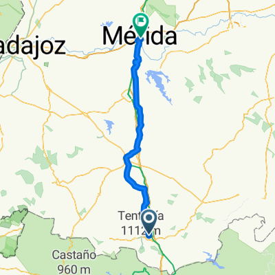
- 12.4 km
- Distance
- 403 m
- Ascent
- 379 m
- Descent
- ---
- Avg. speed
- ---
- Max. altitude

Continue with Bikemap
Use, edit, or download this cycling route
You would like to ride PARAJE DEL MORO or customize it for your own trip? Here is what you can do with this Bikemap route:
Free features
- Save this route as favorite or in collections
- Copy & plan your own version of this route
- Sync your route with Garmin or Wahoo
Premium features
Free trial for 3 days, or one-time payment. More about Bikemap Premium.
- Navigate this route on iOS & Android
- Export a GPX / KML file of this route
- Create your custom printout (try it for free)
- Download this route for offline navigation
Discover more Premium features.
Get Bikemap PremiumFrom our community
Other popular routes starting in Calera de León
 PARAJE DEL MORO
- Distance
- 12.4 km
- Ascent
- 403 m
- Descent
- 379 m
- Location
- Calera de León, Extremadura, Spain
 TENTUDIA-PUEBLA MAESTRE POR LA SOLANA
- Distance
- 41.2 km
- Ascent
- 578 m
- Descent
- 1,128 m
- Location
- Calera de León, Extremadura, Spain
 pantaneta - cabañas -pantaneta
- Distance
- 4.7 km
- Ascent
- 100 m
- Descent
- 101 m
- Location
- Calera de León, Extremadura, Spain
 2ª Etapa: La Cabra Zufre. Variante por la izq. carr. real-Santa Olalla
- Distance
- 53.9 km
- Ascent
- 469 m
- Descent
- 724 m
- Location
- Calera de León, Extremadura, Spain
 Calera de León - Zafra
- Distance
- 109.8 km
- Ascent
- 875 m
- Descent
- 1,193 m
- Location
- Calera de León, Extremadura, Spain
 TENTUDIA, por Calera de León
- Distance
- 8.6 km
- Ascent
- 489 m
- Descent
- 101 m
- Location
- Calera de León, Extremadura, Spain
 SUBIDA AL MONASTERIO DE TENTUDÍA
- Distance
- 19.1 km
- Ascent
- 519 m
- Descent
- 516 m
- Location
- Calera de León, Extremadura, Spain
 2ª Etapa: Cr La Cabra (Monesterio) -variante camino de Cala
- Distance
- 54.4 km
- Ascent
- 487 m
- Descent
- 753 m
- Location
- Calera de León, Extremadura, Spain
Open it in the app