

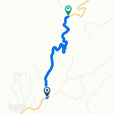
Aigues-Colombiana-cima Cabezo- bajada sur poulset-zetas
A cycling route starting in Aigues, Valencia, Spain.
Overview
About this route
Climb to the geodetic point of Cabezo, 1209 meters altitude
- -:--
- Duration
- 26.3 km
- Distance
- 1,100 m
- Ascent
- 1,105 m
- Descent
- ---
- Avg. speed
- ---
- Max. altitude

Continue with Bikemap
Use, edit, or download this cycling route
You would like to ride Aigues-Colombiana-cima Cabezo- bajada sur poulset-zetas or customize it for your own trip? Here is what you can do with this Bikemap route:
Free features
- Save this route as favorite or in collections
- Copy & plan your own version of this route
- Sync your route with Garmin or Wahoo
Premium features
Free trial for 3 days, or one-time payment. More about Bikemap Premium.
- Navigate this route on iOS & Android
- Export a GPX / KML file of this route
- Create your custom printout (try it for free)
- Download this route for offline navigation
Discover more Premium features.
Get Bikemap PremiumFrom our community
Other popular routes starting in Aigues
 Spain 2019 day 9 Cala D'Or to Torrevieja
- Distance
- 84.5 km
- Ascent
- 301 m
- Descent
- 311 m
- Location
- Aigues, Valencia, Spain
 alic-relle-ort-villa-alican
- Distance
- 95.4 km
- Ascent
- 483 m
- Descent
- 792 m
- Location
- Aigues, Valencia, Spain
 relleu-sella
- Distance
- 87.8 km
- Ascent
- 1,598 m
- Descent
- 1,602 m
- Location
- Aigues, Valencia, Spain
 Aigues-Relleu-Tudons-Orxeta-Pantano-Aigues
- Distance
- 76.9 km
- Ascent
- 1,377 m
- Descent
- 1,385 m
- Location
- Aigues, Valencia, Spain
 Opción inicio marcha
- Distance
- 6 km
- Ascent
- 232 m
- Descent
- 232 m
- Location
- Aigues, Valencia, Spain
 relleu
- Distance
- 13.7 km
- Ascent
- 431 m
- Descent
- 345 m
- Location
- Aigues, Valencia, Spain
 ag<sbn b
- Distance
- 3.2 km
- Ascent
- 252 m
- Descent
- 85 m
- Location
- Aigues, Valencia, Spain
 Recovered Route
- Distance
- 26.3 km
- Ascent
- 564 m
- Descent
- 830 m
- Location
- Aigues, Valencia, Spain
Open it in the app