

Le Tour du Chat
A cycling route starting in Versonnex, Auvergne-Rhône-Alpes, France.
Overview
About this route
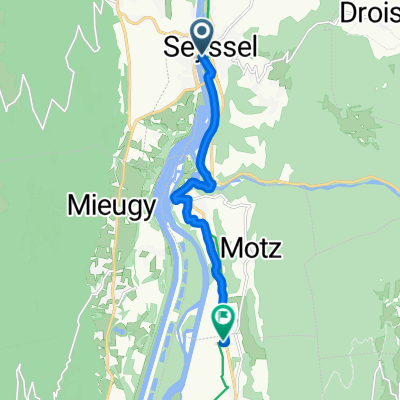
One-day loop starting at Seyssel (74) along the Rhône and extending via the Chautagne to the Savières Canal. Continuing on the Corniche road above Lake Bourget to the Col du Chat, descending through the Savoy vineyards, then returning to Seyssel.
- -:--
- Duration
- 85.1 km
- Distance
- 608 m
- Ascent
- 610 m
- Descent
- ---
- Avg. speed
- ---
- Max. altitude

Route quality
Waytypes & surfaces along the route
Waytypes
Road
10.2 km
(12 %)
Cycleway
6 km
(7 %)
Surfaces
Paved
37.4 km
(44 %)
Unpaved
3.4 km
(4 %)
Asphalt
31.5 km
(37 %)
Paved (undefined)
6 km
(7 %)
Continue with Bikemap
Use, edit, or download this cycling route
You would like to ride Le Tour du Chat or customize it for your own trip? Here is what you can do with this Bikemap route:
Free features
- Save this route as favorite or in collections
- Copy & plan your own version of this route
- Split it into stages to create a multi-day tour
- Sync your route with Garmin or Wahoo
Premium features
Free trial for 3 days, or one-time payment. More about Bikemap Premium.
- Navigate this route on iOS & Android
- Export a GPX / KML file of this route
- Create your custom printout (try it for free)
- Download this route for offline navigation
Discover more Premium features.
Get Bikemap PremiumFrom our community
Other popular routes starting in Versonnex
 Genève le Barroux par l'Ardèche
- Distance
- 503 km
- Ascent
- 2,447 m
- Descent
- 2,439 m
- Location
- Versonnex, Auvergne-Rhône-Alpes, France
 étape 3 jours 1
- Distance
- 35.2 km
- Ascent
- 214 m
- Descent
- 235 m
- Location
- Versonnex, Auvergne-Rhône-Alpes, France
 VR08 Seyssel-Champagneux.kml - VR08 Seyssel-Champagneux.kml_VR08 Seyssel-Champagneux
- Distance
- 54 km
- Ascent
- 262 m
- Descent
- 311 m
- Location
- Versonnex, Auvergne-Rhône-Alpes, France
 Genf-Lyon 2. Etappe
- Distance
- 69.4 km
- Ascent
- 403 m
- Descent
- 430 m
- Location
- Versonnex, Auvergne-Rhône-Alpes, France
 J-2: Back sur la Via Rhona
- Distance
- 83 km
- Ascent
- 149 m
- Descent
- 198 m
- Location
- Versonnex, Auvergne-Rhône-Alpes, France
 von Genf nach Lyon - Tag 3 - von Seyssel nach Belley
- Distance
- 36.5 km
- Ascent
- 267 m
- Descent
- 246 m
- Location
- Versonnex, Auvergne-Rhône-Alpes, France
 8 Quai du Rhône, Seyssel to 155 Rue Stéphane Duc, Serrières-en-Chautagne
- Distance
- 8.2 km
- Ascent
- 97 m
- Descent
- 90 m
- Location
- Versonnex, Auvergne-Rhône-Alpes, France
 Tour du lac du Bourget (89km)
- Distance
- 89.3 km
- Ascent
- 1,656 m
- Descent
- 1,657 m
- Location
- Versonnex, Auvergne-Rhône-Alpes, France
Open it in the app