

Westalpen_8
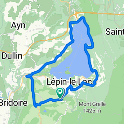
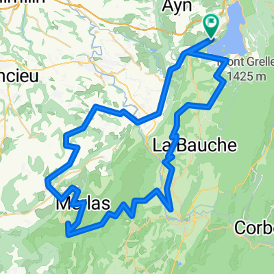
A cycling route starting in La Bridoire, Auvergne-Rhône-Alpes, France.
Overview
About this route
Wegen Regen zwei Kurzetappen zusammengefasst.
Vom Lac d'Aiguebelette nach St. Pierre de Chartreuse und von dort über Grenoble nach La Mure.- -:--
- Duration
- 103.4 km
- Distance
- 1,895 m
- Ascent
- 1,400 m
- Descent
- ---
- Avg. speed
- ---
- Max. altitude

Route quality
Waytypes & surfaces along the route
Waytypes
Busy road
71.8 km
(69 %)
Road
16.9 km
(16 %)
Surfaces
Paved
68.1 km
(66 %)
Unpaved
0.3 km
(<1 %)
Asphalt
66.9 km
(65 %)
Concrete
1 km
(<1 %)
Continue with Bikemap
Use, edit, or download this cycling route
You would like to ride Westalpen_8 or customize it for your own trip? Here is what you can do with this Bikemap route:
Free features
- Save this route as favorite or in collections
- Copy & plan your own version of this route
- Split it into stages to create a multi-day tour
- Sync your route with Garmin or Wahoo
Premium features
Free trial for 3 days, or one-time payment. More about Bikemap Premium.
- Navigate this route on iOS & Android
- Export a GPX / KML file of this route
- Create your custom printout (try it for free)
- Download this route for offline navigation
Discover more Premium features.
Get Bikemap PremiumFrom our community
Other popular routes starting in La Bridoire
 lac novalaise 3
- Distance
- 19.9 km
- Ascent
- 259 m
- Descent
- 258 m
- Location
- La Bridoire, Auvergne-Rhône-Alpes, France
 Mont de Chat 1501+ (1e cat)
- Distance
- 45.3 km
- Ascent
- 1,393 m
- Descent
- 1,393 m
- Location
- La Bridoire, Auvergne-Rhône-Alpes, France
 CduSoleil tronc. I-18
- Distance
- 17.9 km
- Ascent
- 802 m
- Descent
- 795 m
- Location
- La Bridoire, Auvergne-Rhône-Alpes, France
 Plantes du lac avril 2018
- Distance
- 65.3 km
- Ascent
- 1,206 m
- Descent
- 1,207 m
- Location
- La Bridoire, Auvergne-Rhône-Alpes, France
 Stage1_2Draft_Ain17
- Distance
- 58.5 km
- Ascent
- 1,504 m
- Descent
- 826 m
- Location
- La Bridoire, Auvergne-Rhône-Alpes, France
 Mon Tournier depuis la Bridoire
- Distance
- 57.2 km
- Ascent
- 1,052 m
- Descent
- 1,052 m
- Location
- La Bridoire, Auvergne-Rhône-Alpes, France
 Dimanche 24/2 - 3h30 - S P I
- Distance
- 66.8 km
- Ascent
- 672 m
- Descent
- 672 m
- Location
- La Bridoire, Auvergne-Rhône-Alpes, France
 Westalpen_8
- Distance
- 103.4 km
- Ascent
- 1,895 m
- Descent
- 1,400 m
- Location
- La Bridoire, Auvergne-Rhône-Alpes, France
Open it in the app