

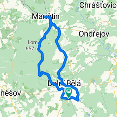
Okruh Myslivna - Žilov - Tlucná
A cycling route starting in Všeruby, Plzeň Region, Czechia.
Overview
About this route
Tlucná - Krašovice - spojka lom - Modrý kříž - Horní Bříza - Žilov - polní cestou Tatiná - Tlucná
- -:--
- Duration
- 20.5 km
- Distance
- 290 m
- Ascent
- 287 m
- Descent
- ---
- Avg. speed
- ---
- Max. altitude

Route quality
Waytypes & surfaces along the route
Waytypes
Track
9.2 km
(45 %)
Road
9 km
(44 %)
Surfaces
Paved
0.6 km
(3 %)
Unpaved
9.6 km
(47 %)
Gravel
5.7 km
(28 %)
Ground
2.2 km
(11 %)
Continue with Bikemap
Use, edit, or download this cycling route
You would like to ride Okruh Myslivna - Žilov - Tlucná or customize it for your own trip? Here is what you can do with this Bikemap route:
Free features
- Save this route as favorite or in collections
- Copy & plan your own version of this route
- Sync your route with Garmin or Wahoo
Premium features
Free trial for 3 days, or one-time payment. More about Bikemap Premium.
- Navigate this route on iOS & Android
- Export a GPX / KML file of this route
- Create your custom printout (try it for free)
- Download this route for offline navigation
Discover more Premium features.
Get Bikemap PremiumFrom our community
Other popular routes starting in Všeruby
 Manětínska 60tka
- Distance
- 59.7 km
- Ascent
- 545 m
- Descent
- 545 m
- Location
- Všeruby, Plzeň Region, Czechia
 Hracholusky - Velikonoce 2010 1/2
- Distance
- 108.9 km
- Ascent
- 872 m
- Descent
- 878 m
- Location
- Všeruby, Plzeň Region, Czechia
 Hracholusky - Velikonoce 2010 2/2
- Distance
- 74.3 km
- Ascent
- 576 m
- Descent
- 576 m
- Location
- Všeruby, Plzeň Region, Czechia
 Bělské kolečko
- Distance
- 21.2 km
- Ascent
- 296 m
- Descent
- 296 m
- Location
- Všeruby, Plzeň Region, Czechia
 Trasa koníků - Luhov, Lipno, Písek
- Distance
- 36.6 km
- Ascent
- 302 m
- Descent
- 309 m
- Location
- Všeruby, Plzeň Region, Czechia
 2011 - Luhov 5
- Distance
- 51.6 km
- Ascent
- 734 m
- Descent
- 734 m
- Location
- Všeruby, Plzeň Region, Czechia
 Luhov 2010
- Distance
- 38.9 km
- Ascent
- 464 m
- Descent
- 464 m
- Location
- Všeruby, Plzeň Region, Czechia
 Horní Bělá - Manětín a zpět
- Distance
- 41.6 km
- Ascent
- 543 m
- Descent
- 526 m
- Location
- Všeruby, Plzeň Region, Czechia
Open it in the app