
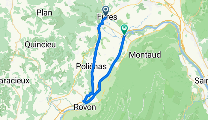
Variante pour TUllins
A cycling route starting in Tullins, Auvergne-Rhône-Alpes, France.
Overview
About this route
Variante pour la sortie du 11 Novembre
- -:--
- Duration
- 23.8 km
- Distance
- 225 m
- Ascent
- 255 m
- Descent
- ---
- Avg. speed
- ---
- Max. altitude
Continue with Bikemap
Use, edit, or download this cycling route
You would like to ride Variante pour TUllins or customize it for your own trip? Here is what you can do with this Bikemap route:
Free features
- Save this route as favorite or in collections
- Copy & plan your own version of this route
- Sync your route with Garmin or Wahoo
Premium features
Free trial for 3 days, or one-time payment. More about Bikemap Premium.
- Navigate this route on iOS & Android
- Export a GPX / KML file of this route
- Create your custom printout (try it for free)
- Download this route for offline navigation
Discover more Premium features.
Get Bikemap PremiumFrom our community
Other popular routes starting in Tullins
 Tullins
- Distance
- 13.9 km
- Ascent
- 45 m
- Descent
- 45 m
- Location
- Tullins, Auvergne-Rhône-Alpes, France
 Itinéraire modéré en Tullins
- Distance
- 12.7 km
- Ascent
- 51 m
- Descent
- 50 m
- Location
- Tullins, Auvergne-Rhône-Alpes, France
 dimpe
dimpe- Distance
- 82.3 km
- Ascent
- 1,395 m
- Descent
- 1,395 m
- Location
- Tullins, Auvergne-Rhône-Alpes, France
 Dimanche 15/4 - S
- Distance
- 64.2 km
- Ascent
- 948 m
- Descent
- 948 m
- Location
- Tullins, Auvergne-Rhône-Alpes, France
 Tullins-Gap
- Distance
- 496.5 km
- Ascent
- 1,982 m
- Descent
- 1,443 m
- Location
- Tullins, Auvergne-Rhône-Alpes, France
 Variante pour TUllins
- Distance
- 23.8 km
- Ascent
- 225 m
- Descent
- 255 m
- Location
- Tullins, Auvergne-Rhône-Alpes, France
 Route de test
- Distance
- 44.9 km
- Ascent
- 512 m
- Descent
- 512 m
- Location
- Tullins, Auvergne-Rhône-Alpes, France
 Rando des Coteaux 90km
- Distance
- 87.6 km
- Ascent
- 1,040 m
- Descent
- 1,040 m
- Location
- Tullins, Auvergne-Rhône-Alpes, France
Open it in the app