

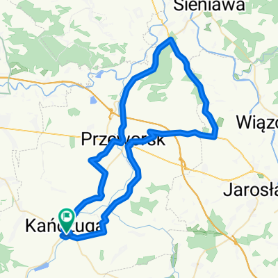
ZASIĘG 2016r.
A cycling route starting in Kańczuga, Subcarpathian Voivodeship, Poland.
Overview
About this route
07.08.2016 DĘBICA-NIWISKA
16.07.2016 POLAŃCZYK-CHREWT
30.04.2016 STALOWA WOLA-BOJANÓW
11.10.2014 ULANÓW
20.08.2014 BIRCZA-ARŁAMÓW
17.08.2014 PRZEMYŚL-BIRCZA
25.05.2013 STUBNO,MEDYKA,PRZEMYŚL
20.07.2013 PRZEMYŚL,DUBIECKO 27.07.2013 USTRZYKI DLN.,WOŁOSATE 14.08.2013 SOŁONKA,TYCZYN 20.08. 2013 KOLBUSZOWA,RZESZÓW
11.11.2013 BACHÓW
15.04.2014 BOGUCHWAŁA,BZIANKA,RZESZÓW
20.07.2014 CIESZANÓW,STARY DZIKÓW
- -:--
- Duration
- 1,965.4 km
- Distance
- 1,451 m
- Ascent
- 1,450 m
- Descent
- ---
- Avg. speed
- ---
- Max. altitude

Route quality
Waytypes & surfaces along the route
Waytypes
Busy road
698.3 km
(36 %)
Road
672.5 km
(34 %)
Surfaces
Paved
1,683 km
(86 %)
Unpaved
35.5 km
(2 %)
Asphalt
1,634.5 km
(83 %)
Paved (undefined)
27.6 km
(1 %)
Continue with Bikemap
Use, edit, or download this cycling route
You would like to ride ZASIĘG 2016r. or customize it for your own trip? Here is what you can do with this Bikemap route:
Free features
- Save this route as favorite or in collections
- Copy & plan your own version of this route
- Split it into stages to create a multi-day tour
- Sync your route with Garmin or Wahoo
Premium features
Free trial for 3 days, or one-time payment. More about Bikemap Premium.
- Navigate this route on iOS & Android
- Export a GPX / KML file of this route
- Create your custom printout (try it for free)
- Download this route for offline navigation
Discover more Premium features.
Get Bikemap PremiumFrom our community
Other popular routes starting in Kańczuga
 Trasa od bajeczna, kańczuga do bajeczna, kańczuga
- Distance
- 100.1 km
- Ascent
- 563 m
- Descent
- 563 m
- Location
- Kańczuga, Subcarpathian Voivodeship, Poland
 #2 GSR "Junior"
- Distance
- 17.3 km
- Ascent
- 145 m
- Descent
- 137 m
- Location
- Kańczuga, Subcarpathian Voivodeship, Poland
 000(KRA) "Walnijmy setkę" (Koło Rowerowe Axtone) Propozycja 1
- Distance
- 96.1 km
- Ascent
- 556 m
- Descent
- 564 m
- Location
- Kańczuga, Subcarpathian Voivodeship, Poland
 # 3 GSR "EDU 9"
- Distance
- 43.2 km
- Ascent
- 380 m
- Descent
- 388 m
- Location
- Kańczuga, Subcarpathian Voivodeship, Poland
 113/SIENIAWA-KURYŁÓWKA-ŁAŃCUT
- Distance
- 113.4 km
- Ascent
- 261 m
- Descent
- 261 m
- Location
- Kańczuga, Subcarpathian Voivodeship, Poland
 65 (64/16) Przeworsk-Tryńcza-Pełkinie-Krzeczowice
- Distance
- 64.6 km
- Ascent
- 134 m
- Descent
- 134 m
- Location
- Kańczuga, Subcarpathian Voivodeship, Poland
 68 km Gminny Szlak Rowerowy "K-ga Max" (Kańczucka pętla)
- Distance
- 68.2 km
- Ascent
- 710 m
- Descent
- 715 m
- Location
- Kańczuga, Subcarpathian Voivodeship, Poland
 Zielona do Węgierska 39A
- Distance
- 19 km
- Ascent
- 163 m
- Descent
- 204 m
- Location
- Kańczuga, Subcarpathian Voivodeship, Poland
Open it in the app